Morgan Moments – Damages to Cheesequake State Park by Hurricane Sandy
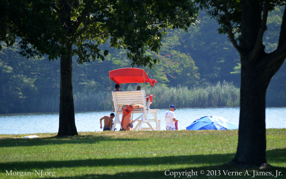
Hooks Creek Lake in Cheesequake State Park in August 2012. This was Two Months before Hurricane Sandy Struck.
I’ve been trying to find information regarding the massive storm surge which came on shore from Raritan Bay hitting Morgan, South Amboy, Sayreville and all the communities lining Raritan Bay in the dark evening hours of Monday, October 29. 2012. While I have yet to find sufficient information regarding this surge, which knocked over the 119-year old Old Orchard Shoal Lighthouse off the south shores of Staten Island, flooded portions of South Amboy and Sayreville, badly mangled the NJ Transit railroad tracks in the back yard of my Morgan childhood home, destroyed or greatly damaged Morgan based marinas, and caused significant damage to Cheesequake State Park, I did find a report which identified specific damages done in the park.
The report titled “ASSESSING THE IMPACTS OF HURRICANE SANDY ON COASTAL HABITATS” was written by The American Littoral Society (ALS), in partnership with the Hudson River Foundation and the Rutgers University Grant F. Walton Center for Remote Sensing and Spatial Analysis. The Littoral Zone is the part of a sea, lake or river that is close to the shore. Per their web site, The American Littoral Society promotes the study and conservation of marine life and habitat, protects the coast from harm, and empowers others to do the same.
The ALS was tasked by the National Fish and Wildlife Foundation to coordinate a regional assessment to rapidly evaluate the quantitative and qualitative environmental impacts associated with Hurricane Sandy. The area covered by the report was much larger just than the westernmost part of Raritan Bay. It analyzed the mid-Atlantic coastal areas and includes the Delaware Bay, coastal New Jersey, the Hudson-Raritan Estuary, Jamaica Bay and Long Island Sound. The Final Assessment Report, submitted on December 17, 2012, focused on the physical effects the storm had on coastal habitats and the target species which depend on them. It also identifies realistic opportunities to address and remediate critical storm-related challenges facing those species.
Here are excerpts from the report:
Cheesequake State Park
Cheesequake State Park is uniquely situated between suburban southern New Jersey and urban northern New Jersey, is bisected by the Garden State Parkway, and sits adjacent to the Raritan Bay. It is home to a variety of habitats, including open fields, saltwater and freshwater marshes, a white cedar swamp, pine barrens, and a northeastern hardwood forest and suffered several different types of damage from Sandy, including the following:
- The loss of over 300 trees, including 100-year old oaks and several Atlantic white cedars, reducing habitat for numerous species, such as woodpecker, screech owls, flying squirrels, changing the park aesthetic and creating a void that has the potential to be filled by invasive/nuisance species.
- There is a 4 to 6 foot deep layer of organic tidal debris in the marshes comprised mostly of reeds and other vegetation, combined with tires, duck blinds and other man-made structures. Estimated to weigh approximately 100,000 tons, this debris layer will stunt the growth of vegetation impacting not only the crabs that dwell there, but the kingfishers, herons and gulls that feed upon them.
- Several vernal pools in the lowland forest were destroyed by the storm surge. These pools are prime habitat for a variety of frogs, toads and salamanders.
- The tremendous tidal surge caused saltwater intrusion into the cedar swamp populated by Atlantic white cedars. In addition, there was significant saltwater intrusion into Hooks Creek Lake, a freshwater lake that is habitat for a variety of species of fish that were killed off by the high salinity levels.
- The saltwater intrusion at Hooks Creek Lake is exacerbated by the fact that the dam at the lake area and its associated culvert has been compromised by the storm and the outflow pipe is broken. This habitat is extremely valuable to the passage of migratory American Eel and Mummichog. In addition, the inflow pipe from Landing Creek to Perrine Pond was damaged.
Hurricane Sandy created two specific opportunities for invasive species. One was created in areas where a large number of trees were felled. The second opportunity exists in areas where intertidal and near shore plant species were destroyed or damaged.
Many of the problems experienced were the result of the failure of man-made structures in the face of the storm such as Cheesequake Creek State Park’s Hooks Creek Lake dam/culvert.
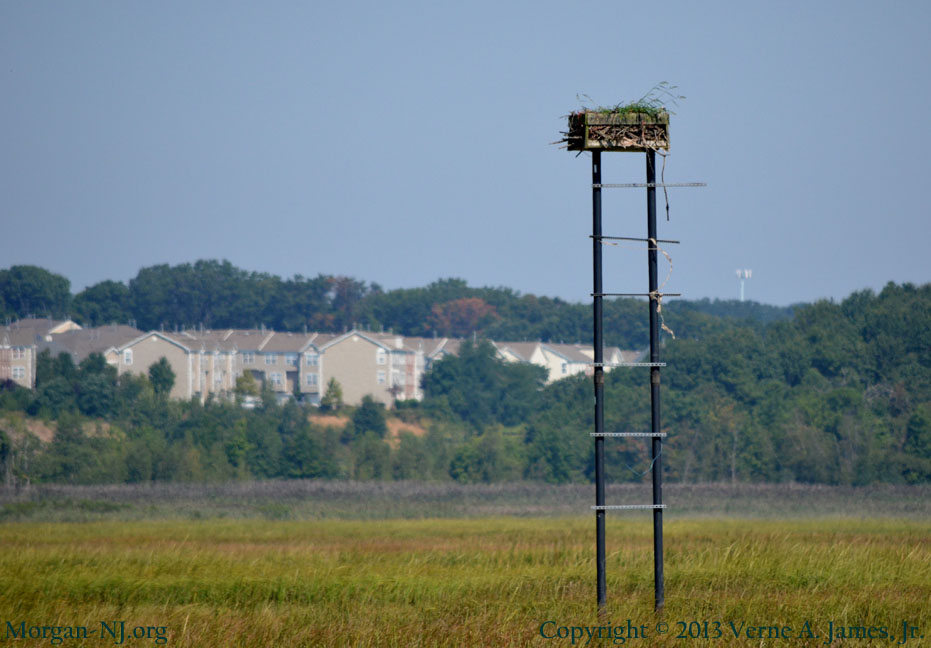
Osprey Nesting Platform in Cheesequake State Park in August 2012. This was Two Months before Hurricane Sandy Struck.
The Superintendent of Cheesequake Park submitted four priority project summaries also known as high-priority remediation opportunities:
- Requesting funds to restore two osprey [Pandion haliaetus] nesting platforms that were knocked over by the storm before the birds return from South American nesting grounds. The timeline published was January 1, 2013 – March 15, 2013 ($4,500);
- Rebuild the vernal pools in the lowland forest and create escape structures for hatchlings. The timeline published was January 1, 2013 – February 15, 2013 ($9,500);
- Repair the damage to the outflow pipe at Hooks Creek Lake by creating a temporary outflow structure and repairing the spillway box and piping. The timeline published was January 1, 2013 – April 15, 2013 ($25,000);
- Restock Hooks Creek Lake with native fish such as bass, catfish, sunfish, carp and crappie, that were killed off by increased salinity levels caused by the over 8 feet of salt water flooding. The timeline published was June 1, 2013 – November 15, 2013 ($3,500).
As if this wasn’t enough, in addition, the report also mentions these pleasant statistics:
Flooded by the storm surge and rendered inoperable due to power outages, several major sewage treatment plants released raw or partially treated sewage into local waterways. The Passaic Valley Sewerage Commission treatment plant released an estimated 400 to 500 million gallons of untreated wastewater into the Newark Bay for several days, with the total amount discharged estimated to be in the billions of gallons. The Middlesex County Utilities Authority treatment plant in Sayreville, New Jersey released about 300 million gallons per day into the Raritan River for an unknown period of days. State officials issued advisories for the waters of the Hudson, Raritan, Passaic and Hackensack Rivers, Newark and Raritan Bays and the Arthur Kill and the Kill van Kull.
On the good news side, here is an article which includes the Osprey’s return to Cheesequake State Park in May 2013.
Here is a Google Map showing the Osprey Nest Monitoring Project.
A video of Osprey branding at Cheesequake State Park.
New Jersey Osprey Project on Facebook.
Two additional web postings about the Ospreys in Cheesequake State Park and the area.
Photos of Osprey Banding in Cheesequake State Park.
Geocaching site for watching Ospreys at Cheesequake State Park.
I want to know if Hood Lake is a man made lake, or was it there and the beach was built around it. I was there today for the first time I found it to be a very relaxing time. We went with our 2 year old granson,and found it very safe for him. Hope to return many more times.
Hi, Do you mean Hook’s Lake? At the moment I an not sure if it is real or man made. It looks man made to me and I would be surprised if the sand wasn’t trucked in. We’ll see if we can find out the answer for you.