Morgan Memories – Trolley Tracks Thru Morgan
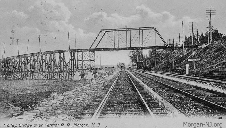
Jersey Central Traction Trestle and Bridge Over the New York & Long Branch Railroad Circa 1905.
After spending the first 21 years of my life in Morgan just up the street from where Route 35 crosses over the railroad tracks, imagine my surprise a couple of decades later when I encountered the picture post card at the top of this page. It looked so much like the Route 35 north bridge over the railroad tracks – yet it wasn’t. Like so many other things, hopefully being addressed by this web site one by one, I never knew that once there was a trolley which ran through Morgan.
But there was!! Its name was the Jersey Central Traction Company (let’s just call it the JCT) and the majority of its route would seem very familiar to anyone who has ever traveled from Laurence Harbor to South Amboy. Opened for passengers on March 15, 1905, until the automobile put trolley lines out of business, the JCT was the main way to travel between Perth Amboy and the Atlantic Highlands.
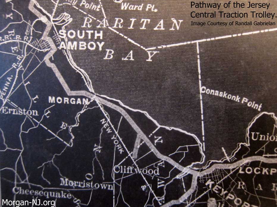
Jersey Central Traction Company Route Map. Image Courtesy of Randall Gabrielan.
So specifically where in Morgan did the JCT run? Thanks to a number of people (the late Joseph Eid, Joseph Grabas, Joyce Elyea and Randy Gabrielan), the answer is pretty much contained on this page – including what sides of the streets the tracks were on!

1919 Sanborn Fire Map Showing the Route of the Jersey Central Traction Company from Cheesequake Creek to Present Day Tyler Street in Morgan, NJ. Image Courtesy of Princeton University Library. http://gisserver.princeton.edu:81/navigatorMapViewer.htm?map=16630
Let’s start with where the JCT crossed Cheesequake Creek. You can see images of the two different bridges (one replaced the other) by clicking on this Morgan-NJ.org link about the Bridges of Cheesequake Creek. Right after crossing Cheesequake Creek, the trolley would climb up the JCT trestle in order to be able to cross over the New York & Long Branch (NY&LB) Rail Road. The option to build a trestle and bridge, versus having a grade level crossing of the trolley with the railroad, was most likely selected for a number of reasons. The first would have been that the railroad wasn’t interested in anything having to do with the trolley which the railroad viewed as a form of competition. Railroads of the day did their best to do anything to slow down the building and extension of trolley lines – especially when it came to where the two sets of tracks would need to cross. In this area of Morgan, the only possible place to have had a grade level crossing of the NY&LB RR would have been where present day Old Spye Road ends at the railroad tracks. If this option had been selected, another issue the trolley would have faced was the width of what is now Old Spye Road as it goes up the hill to meet up with present day Route 35. It would have been pretty narrow to support both a road and a trolley. Hence the trestle and bridge over the railroad. It would have been more convenient however for the passengers that needed/wanted to transfer between the two methods of transportation if the railroad and the trolley lines actually intersected. The intersection would have been right at the NY&LB’s Morgan Station. That didn’t occur which meant that those that wanted to transfer needed to walk on the causeway dam across the original mouth of the Cheesequake Creek between Morgan Station and the trolley stop at the base of the trestle at Morgan Bridge.
So the Jersey Central Traction Company trolley crossing over the New York and Long Branch Railroad was done via the truss bridge shown at the top of this page. After the trolley line ended service in the summer of 1923, this bridge was replaced in 1924 by the current Pratt truss bridge which, nearly 90 years later, still supports the two north bound lanes of Route 35.
Now at the top of “Morgan Heights” (an old phrase I also had never heard in my two decades living on the bluff), the trolley right-of-way crossed over Cliff Avenue, Morgan Avenue, First Street, Haussling Place, and Main Street (now known as Tyler Street) before straightening out by what is now Midland Avenue. This pathway is now occupied by the north bound lanes of Route 35.
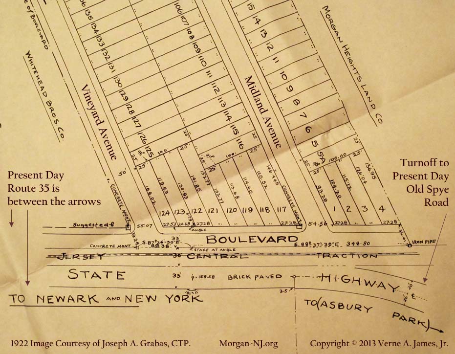
Where the South Amboy and Keyport Turnpike Curved into Present Day Old Spye Road in Morgan, NJ. From the August 1922 Wessco Reality Company Map of Bayview Manor – Section 4. Surveyed by Mason + Smith, Civil Engineers, 309 Madison Av, Perth Amboy, N.J. and Traced from the Original on October 10th, 1939 for W. P. A. Project 6385-12. Map No. 1006, File No. 584, Filed Mar. 13, 1923. Image Courtesy of Joseph A. Grabas, CTP.
From Midland Avenue and going west, the trolley line stayed on the north side of what was known then as the “County Road” or “Amboy to Keyport Road.”
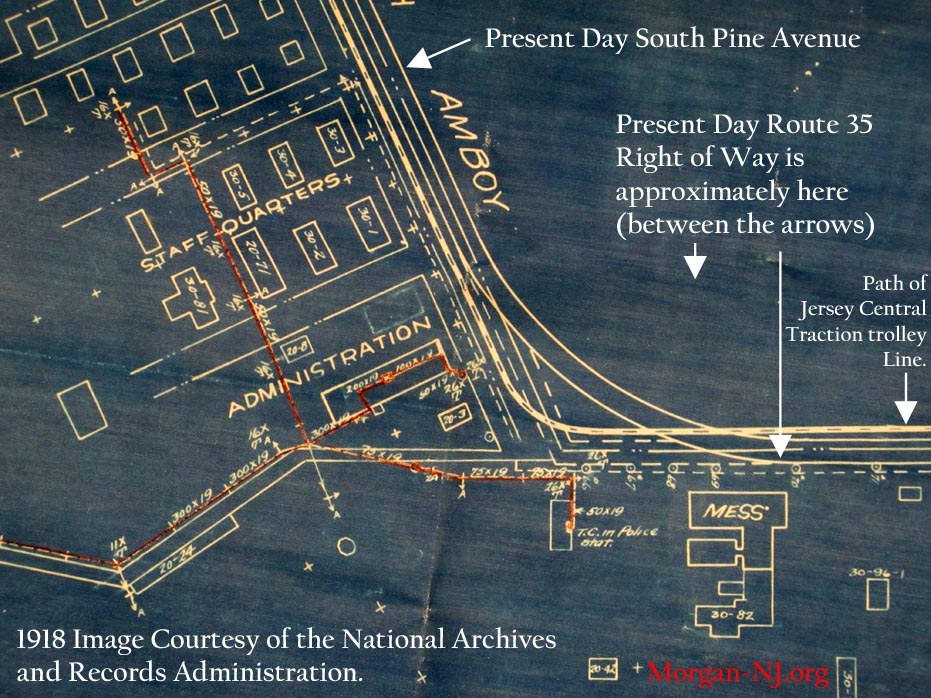
Where the South Amboy and Keyport Turnpike Curved in the pre-Route 35 Days in Morgan, NJ. From the 1918 Map Showing General Location of the Lines of the New York Telephone Co. Inside the Plant of the T. A. Gillespie Plant. Image Courtesy of the National Archives and Records Administration.
Right about where present day Dolan Avenue is located, the JCT crossed over the older configuration of South Pine Avenue onto the west side of South Pine Avenue.
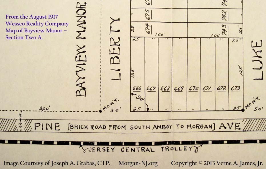
Pine Avenue at the Intersections of Liberty Street and Luke Street in Morgan, NJ. From the August 1917 Wessco Reality Company Map of Bayview Manor – Section Two A. Surveyed by A. T. McMichael, Civil Engineer, Post Office B’ldg, South Amboy, N.J. and Traced from a Blueprint on June 20, 1939 for W. P. A. Project 3025-12. Map No. 915, File No. 456, Filed Feb 4, 1920. Image Courtesy of Joseph A. Grabas, CTP.
From this point, the JCT stayed on the west side of South Pine Avenue as it headed to South Amboy. This is the part which gets interesting, however. At some point, the JCT made a 90 degree left turn (west) off of present day South Pine Avenue then, after a little over 100 yards, made another 90 degree right turn (north) in order to connect with Feltus Street. If you don’t have a map confirming exactly where this set of turns occurred (like we thought we didn’t have) you could make a good guess using these other references:
- Hand drawn map contained in Mr. Joseph Eids’ authoritative 1981 book, “Jersey Central Traction Co. Trolley to the Bayshore.”
- August 1917 Wessco Chart from Luke Street to Liberty Street showing the JCT on the opposite side of South Pine Avenue shown above.
- May 1916 Wessco Chart with Manor Street, Grand Street and Wessco Street NOT showing JCT on the opposite side of South Pine Avenue.
- The below HistoricAerials.com image showing the area around South Pine Avenue and Wessco Street in 1940 compared to 2007.
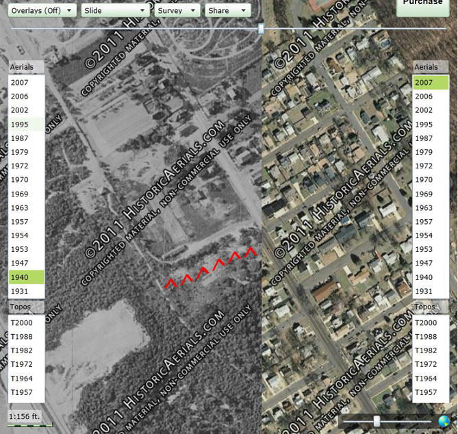
HistoricAerials.com Image of South Pine Avenue & Wessco Street Area in 1940 vs. 2007. Image Courtesy of HistoricAerials.com.
This image from Historic Aerials (one of my favorite web sites!) shows an aerial view of the area around present day South Pine Avenue & Wessco Street – just south of Christ Church Cemetery. 1940 is on the left and in black & white. 2007 is in color and on the right. The years split right where Wessco Street intersects with South Pine Avenue (halfway up the image). At this point, you can easily see how in 1940 there was a path that at one time turned left off of South Pine Avenue, went in a little bit before turning right at the long building, and headed toward Feltus Street. Looking at the harder to see 1931 map on Historic Aerials (not shown here), you’ll note that the pathway is more delineated and that long building had not yet been built.
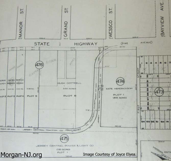
New Jersey State Tax Department Map from October 6, 1932 Showing the Right-Of-Way of the Jersey Central Traction Company Trolley Line Between Present Day South
Pine Avenue and Feltus Street. Image Courtesy of Joyce Elyea.
At this point you’ll then rediscover a gem which had previously been provided to you by the amazing Joyce Elyea! Here is a State Tax Department map from 1932 which shows precisely where the JCT turned from South Pine Avenue to go to Feltus Street! There are even details regarding distances. Even better, the turnoff is exactly where you thought it might have been!
Notice that the property marked with 475 in a circle belonged to Jersey Central Power & Light Company (hence the name “Jersey Central Traction”). You’ll note that today this is the site of JCP&L substation containing power transformers.
Morgan, as a part of the Borough of Sayreville, ends politically where the JCT right-of-way meets Feltus Street at the border with the City of South Amboy. From Feltus Street the JCT turned right onto Bordentown Avenue, left onto Stevens Avenue, and right onto Main Street. At the Camden & Amboy Railroad overpass, it went under the railroad then along the river until turning right onto the county bridge across the Raritan River into Perth Amboy. On Bordentown Avenue between South Pine Avenue and Stevens Avenue, it was on the north side of the street with the Public Service Railway being on the south side of the street. There was a time when the bridge over the Raritan River Railroad – located just west of Stevens Avenue but essentially unrecognizable these days as a bridge – had to be widened to accommodate the two sets of tracks and the growing number of personal automobiles.
South Amboy Citizen – February 12, 1916.
No doubt in the near future the Board of Freeholders will extend the pavement from the city line on the Morgan road along Pine and Bordentown avenues to Stevens avenue. Before this work is started some effort should be made to have the bridge on Bordentown Avenue over the Raritan River Railroad widened to the full width of the street. With two trolley tracks running over this bridge it is now too much congested with traffic and dangerous. It forebodes some serious accident sooner or later, and with paved roadway and correspondingly increase in speed of motor traffic the danger is augmented. Safety first should be our motto, and now is the time to urge the widening of this bridge. Get busy, you who have the authority to act.
It isn’t clear to me yet where the trolley stops were in Morgan and South Amboy. We know from this picture post card image that there was a “Trolley Waiting Room” between the trestle and the bridge over Cheesequake Creek. Per Mr. Eids’ book, there were JCT “sidings”, i.e., where a short piece of track branches off in parallel with the main line, at Morgan Beach, near the intersection of present day Route 36 / Old Spye Road (Morgan Heights) and Feltus Street near Bordentown Avenue.
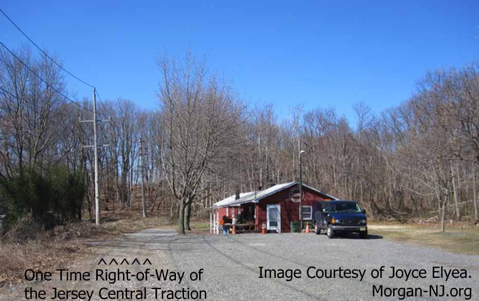
Looking West from South Pine Avenue Towards the BayShore Rod and Gun Club. Image Courtesy of Joyce Elyea.
Here is what that turnoff of South Pine Avenue near Wessco Street looks like in recent years! That long building shown on the 1940 map is still there and, as I understand it, is the Bayshore Rod and Gun Club.
Wouldn’t it have been amazing to have taken a trolley ride on this route? Of course if you had, you would be over 90 years old as of the time of this writing. If you actually did or if any of our readers have a friend or relative that actually did, I would LOVE to include your/their story in an update to this page. Please contact me below.
Please contact me. I grew up next to the bay view rod and gun club and as a young kid I dug at the bend of the track area behind the building and found spikes from the trolley tracks and pieces of a pot belly stove.
That is the Bay View Rod and Gun Club Inc we are 85 years old and still operating at this location on South Pine Ave, Morgan NJ
My grandfather was fatally injured at this intersection c.1921 falling from the trolley. He lived in Perth Amboy but commuted to Union Beach for work. Later the family sued but lost. More info available. How long was the trolley from Perth Amboy to Union Beach where many wealthy people had homes nearby? Please some feedback.
Sorry, we don’t really have that type of information. Thanks for asking. Which intersection are you talking about? Sad about your grandfather.