Morgan Memories – Henderson’s Esso Station
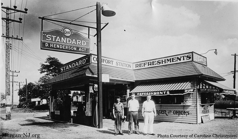
Henderson’s Esso Station, Morgan, NJ, Circa 1932. Photo Courtesy of Caroline Christensen.
A few months ago Caroline Christensen, a school mate from high school, posted an image which she had kept as a remembrance of her late father, of “Henderson’s Esso Station” on the Facebook group, “Things That Aren’t There Anymore”. Caroline indicated that “Henderson, Morgan, NJ” was hand written on the back of the photo. A number of Morganites tried to place the location of where this building would have been situated but there was no definitive answer. Caroline was gracious enough to allow for me to scan the photo and post it on this web site – thanks, Caroline!
As you can see, it is a very old photo though within the image the gas station looks pretty new. It is possible that this photo was taken around the time when the gas station first opened – whatever year that was! One of the great things about this web site is hearing from people who either currently live in Morgan or lived in Morgan at one time. One of these readers is a lady named Mildred who used to live in the house located on the north side of Route 35 at the intersection of Tyler Street. For at least the last 20 years, and probably longer, this building has been occupied by Archie’s Boat Tops. Mildred lived in Morgan in the years prior to and during the first year of World War II.
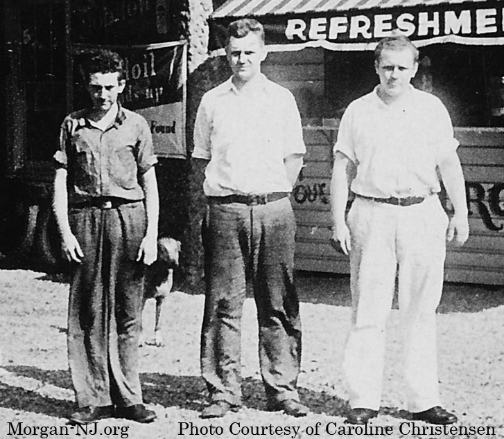
Left to Right: William H. Henderson, Edward Pitt, and Raymond P. Henderson.
Mildred identified two of the three men in the photograph. According to Mildred, “Don’t know who first man is. Middle man is Edward Pitt and he married Helen Baker of Laurence Harbor. Beside him is his father I am pretty sure.”
Like the location of General Morgan’s house in the mid-1800’s, here is my thought process (as well as some observations) regarding where I think this gas station would have been located, if this really was a gas station once located in Morgan:
- The signs on the station indicate the trade name “Esso”. “Esso” is the phonetic rendition of the initials ‘S’ and ‘O’ from “Standard Oil” Company of New Jersey. Standard Oil of New Jersey was one of the 33 companies created after the breakup of the Standard Oil company in 1911 following the US Supreme Court decision that it was an illegal monopoly. The name was brought out in 1926. From this we know that this photo was taken no earlier than 1926. The name “Esso” was later changed to “Exxon” in 1972 then to present day “ExxonMobile” after the 1999 merger.
- The vehicles on the left side of the photo look like they have 1920s era grills. There is a rectangular curved top radiator in the front of the vehicle with large round headlight cowlings on either side.
- Analyzing the power polls shows that the road on the left side of the photo curves to the right.
- Route 35 has always been the only major road going through Morgan.
- What is now known as Route 35 was a two lane road in the mid-1920’s. I believe it was designated as Route 4 at the time.
- No obvious trolley polls are in the image near the road on the right side of the photo. The trolley through Morgan was out of business by 1923 and the road route was modified by 1925 to cross over the railroad tracks using the then newly built, present day bridge supporting the north bound two lanes of Route 35.
- We can’t tell from the image whether or not the road surface was paving stones (circa 1916) or concrete (probably circa mid-1930’s).
- Up until the mid-1930’s, when the road bed was extended to its current right of way, present day South Pine Avenue was part of Route 35.
- The only right turn on Route 35 during the presumed time frame shown in the photo (late 1920’s?) would be either where present day Old Spye Road is or where Route 35 curved toward present day South Pine.
- The sign on the building to the left of the gas station appears to read “Jersey Central Realty Company”.
- The square sign on the light pole says “Authorized Standard Station”.
- The round signs on the top of the gas pumps say “Standard”.
- Notice the CocaCola sign on the ground on the right side of the building under where it says “Hot Franks”.
- Angles of the shadows. If this is the morning sun, we would be looking toward the northwest, i.e., the gas station would be on the north side of the road. If this is the afternoon sun, we would be looking toward the southeast, i.e., the gas station would be on the south side of the road.
- IF we were looking toward the northwest AND this is Route 35 THEN this would be somewhere near the area where present day Route 35 curves to the right toward South Pine Avenue while heading toward South Amboy. The problem with this is that there would be a hill on the right and the road would start to go uphill. It doesn’t appear to be doing that.
- IF we were looking toward the southeast AND this is Route 35 THEN this would be somewhere near the area where present day Route 35 curves to the right near present day Old Spye Road. The station would therefore be on the south side of the road.
- Mildred indicated “Henderson’s did have a gas station on Route 35 across from our house” and “The gas station was on the right side of Rt. 35 going South” which would place it right around the section of present day southbound Route 35 just around where Old Spye Road branches south. Mildred also implied that this gas station was probably near to [or perhaps became] Pitts Restaurant where “I had my first job working for $1.”
January 2017 Update!
Thanks to Ted Henderson for providing an update which helped to resolve many of the questions about this photo (and for proving me to be correct about my deductions about its location)! According to Ted, the image is likely from circa 1932, two of the three people in the photo are his father William H. Henderson and Uncle Raymond P. Henderson (see “The Lore of the Chicken Farmer”), and the station was located on Route 35 South. A BIG thank you to Ted!

1940 Aerial image of Henderson’s Esso Station (center of the image) surrounded by Route 35 above it (to the north), Old Spye Road on right side (on the east side) and the Route 35/Old Spye Road transition road on the left and bottom side (to the south).
When you look at this 1940 aerial photo from HistoricAerials.com, you will indeed see Henderson’s Esso located in the island where Route 35 meets Old Spye Road.
Route 35 underwent many changes between Cheesequake Creek and the Raritan River between the latter part of the 1930s up through World War II. Route 35 was rerouted off of present day South Pine Avenue onto a brand new 4 lane section to the west. The new portion intersected with Route 9 in what, nearly 80 years later, remains a horrible intersection for two major roads – especially in the winter. Going north from there, the two roads share lanes for about a mile and a half until Route 35 breaks off to flow onto its previous path to the Victory Bridge (original bridge opened in 1926, replacement bridges opened in 2004 and 2005) and Route 9 flows onto the Edison Bridge (opened October 1940).
Up until 1940, between Cheesequake Creek and South Pine Avenue, Route 35 had one lane going north and one lane going south. Between the time of this 1940 photo and HistoricAerial.com’s 1947 aerial photo, the current Morgan Bridge was built (opened 1943) and Route 35 was widened to two lanes in each direction between Cheesequake Creek and South Pine Avenue. In support of this, the present day two lane bridge on Route 35 south over the railroad tracks (NJ DOT Structure #1222152) was opened in 1945. Widening of Route 35 from two lanes to four, with two lanes in each direction, would have been in the plan from the time it was split off from South Pine Avenue.
Hence, the widening of Route 35 marked the end of Henderson’s Esso and Haussling Place on the south side of Route 35 as witnessed by their absence in the 1947 HistoricAerial.com photograph.
Originally posted July 21, 2013. Updated January 4, 2017.
Hi Vern: This picture, I believe, puts this gas station on RT 35 south. If you look in the background you can see Raritan Bay. If it was on the north of 35, where Archies Boat top is, it would where the Evigans lived. Don’t forget that 35 went down Old Spy Road for a while. I could be wrong to. Just trying to help. George