Morgan Artifacts – The Dock of the Bay
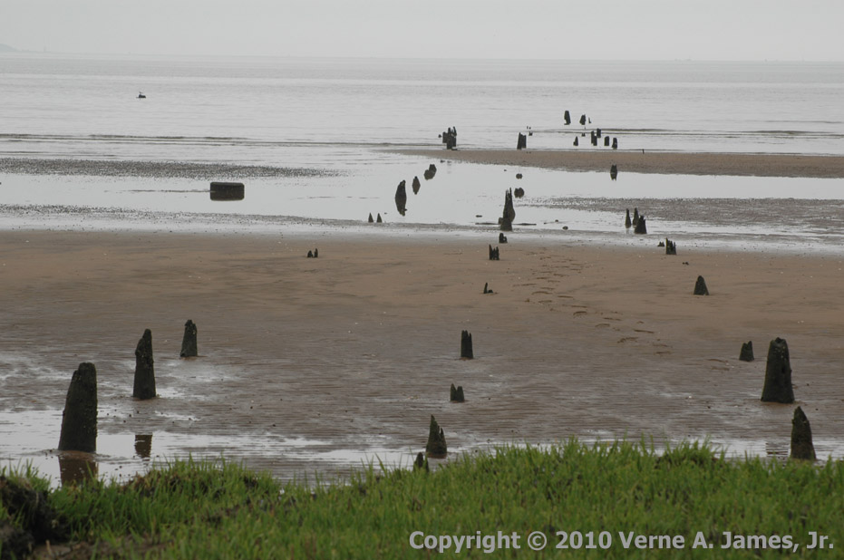
Ruins of the Raritan Bay Dock in Morgan.
Jutting out into Raritan Bay in the southern most (Morgan) portion of Raritan Bay Waterfront Park is the remains of an old dock. What little is left of the structure are the short wooden pile stumps erupting out of the sand. It isn’t clear to me what the real name of this dock was but somehow I concluded it was perhaps called Perrine Dock. I don’t know where I got that information so it may not be correct.
It also isn’t clear how any vessel could have floated to the dock since it is so close to the shore and the bay is very shallow at this part. At low tide, all of the pile remains are totally surrounded by sand with no water. Perhaps it wasn’t always this way in this area. The sludge from the dredging of the Raritan Bay channels in the 1950’s was deposited in what now is the Raritan Bay Waterfront Park. Most likely some of the spillage flowed over to and filled in the area of the dock remains. The 1934 Raritan Bay survey (see illustration and the to-be-reposted write-up), which occurred prior to the dredging, showed depths around the dock of one foot at low tide. This survey also shows the dock as having been in the shape of the letter “L”. The stem (i.e., longest part) traveled from the shoreline into the bay in an east northeast direction where it then turned 90 degrees to the right (south southeast). This short part, which was parallel with the shoreline, must have been were the boats tied up to the dock. The remains of the dock seen in the 1940 aerial image on HistoricAerials.com (see the to-be-reposted write-up) show just the short side of the dock.
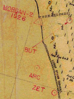
Portion of the 1934 U.S. Coast and Geodetic Survey of Raritan Bay Showing the Dock.
I’m surmising but most likely this dock would have used by local farmers to load produce onto boats for transportation to other places, including possibly New York City. Possibly it might have also helped provide supplies brought in from elsewhere. Someone on one of the Morgan/Sayreville/South Amboy Facebook groups indicated the dock was used for clay. That seems more plausible since there was a clay pit right where the railroad tracks are now starting, I would guess, about 100 years before the railroad went through. There is actually much more I don’t know about this structure than there is that I do know. I don’t know when it was built, by whom, why, what it really was used for, when it stopped being used, or when it fell into ruins. I do know that there was a dock there and all that was left during and after my time in Morgan were the piling stumps. As of my 2012 visit, I was no longer able to even find the remains of the posts so perhaps it is all totally gone now.
This dock does not show on the 1886 Raritan Bay survey (see the to-be-reposted write-up) but can be seen – if you are looking for it and able to find it – in the episode of the NBC TV show “Mercy” which was partially filmed in Morgan and South Amboy in January 2010 (see the to-be-reposted write-up).
If anyone with Morgan knowledge has any information regarding this dock, please make an entry in the Comments section below.
Originally posted on March 7, 2010.
Verne, I think the depth merkings on your map segment indicate fathoms not feet. 1 fathom = 6 feet.
Hi Glen! Thanks for your feedback! Based on your comment, I went back to the original source material from the U.S. Coast and Geodetic Survey (Hydrographic Survey No. 5636) to see what units the measurements were in. It indicates “SOUNDINGS IN FEET at Mean Low Water”. I was back in Morgan in August 2013, after Hurricane Sandy, and there is still no sign of the pilings. It’s all gone now and there is a lot more sand by the railroad which was washed in. Verne
I recently lived in a development on a pier that once held a former Ford model A and T assembly plant. In its day it held berths for not only a deep water port for large deep draw freighters, but also for the rail barges that carried loaded freight cars across The Hudson from the Jersey Central line to the New York Central tracks in Manhattan. Today there is only a shallow tidal marsh which is completely dry at low tide. Nature takes its course. I suspect there’s no guessing how deep the water around this pier may have once been.