Morgan Landmarks – Great Beds Lighthouse
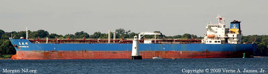
Great Beds Lighthouse in Raritan Bay Dwarfed by a Medium Sized Tanker Ship.
What’s in a Name?
After having seen it from our living room couch through the bay facing windows all my life and water skiing around it as a kid, it didn’t occur to me to ask if that white lighthouse with the black base in the bay had a name… until 2008. Just like the railroad tracks, the Cheesequake Creek jetty, and Coney Island across the bay, from my perspective in my youngest days, it had always been there. Well, of course it had not always been there but from the perspective of the 20th and 21st centuries, it had always been there.
Upon learning its name a number of other questions instantly popped up, the resolution of which explained another curious childhood observation to be covered later. The name of the lighthouse is Great Beds Lighthouse. On the surface, it is a strange name for sure. Why “Great Beds”? Makes you think of a mattress store. Why then “Great Beds”? The short answer is that it has to do with oysters – the great beds of oysters which were located in that portion of Raritan Bay up until the early part of the 20th century when pollution from the industrialization of the Raritan River and the Arthur Kill (“Kille” is middle Dutch meaning “river bed”) effectively ruined them.
What’s the Story?
So the story goes back to 1868, the latter part of the 19th century and just a few years after the end of the Civil War, when local ship owners and businessmen petitioned for the building of a lighthouse. I haven’t however found the specifics of “why” yet. Perhaps the petitioners believed there needed to be some form of marker to warn mariners of the great beds of oysters near the confluence of the Raritan River and the Arthur Kill into Raritan Bay. Perhaps it was to protect the beds themselves, or maybe there was another reason. Hopefully we will all find out at some point and I’ll modify this page accordingly.
Lighthouse Characteristics
Great Beds Lighthouse is of the type of lighthouse known as a “Caisson”. The name stems from the method used for construction which has the lighthouse structure resting on top of a watertight structure known as a “caisson” (Old French for “large box”). This lighthouse type is also known by other names such as “Sparkplug” or, before the days of the automobile, “Coffee Pot”. Some places also call them “Bug lights” because of their resemblance to a bug from a distance. Great Beds is one of the earliest lighthouses of this type. During the time Great Beds was built, many other caisson lighthouses were in the process of being planed or constructed. In fact, there were nearly 50 caisson lighthouses built in the US, primarily in the northeastern states, between 1871 and 1926.
Construction Delays
There are reports that construction was delayed from the 1868 petition for at least a decade. Even worse, before the lighthouse was finished, a boundary dispute erupted between New Jersey and New York (the lighthouse apparently was on or near the state boundary). Progress was made when the state of New York ceded 8.83 acres underneath Raritan Bay for the building of the lighthouse. Click here and scroll down to see the New York State Law which then made it all possible:
Article 3 – Cessions to the United States
State Law 28 – Cession during use for purposes thereof, with reservation of right to serve process.
Section 5 – In Raritan Bay…
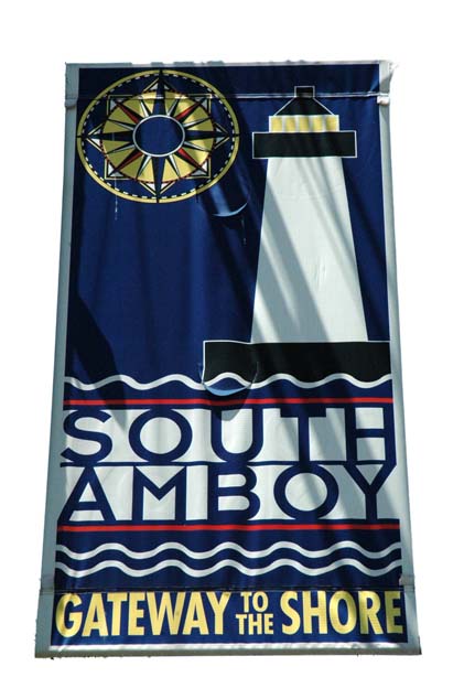
Great Beds is the Adopted Symbol for the City of South Amboy, New Jersey.
Construction Aspects
Again, I don’t have any records – yet – discussing the details of when the construction actually started, how long it took, how many and what type of vessels were involved (ships were still primarily powered by the wind at this time), how many people worked on the project, where the lighthouse was fabricated, where the equipment was staged, what the name of the contractor was, etc. Some web sites indicate caisson lighthouses were prefabricated on land, barged to site and assembled using floating cranes. Perhaps that is what happed with Great Beds. Perhaps even, the now gone piers of South Amboy were utilized.
Building and running of lighthouses at this time was handled through a United States Federal Agency, created in 1852, named The United Stated Lighthouse Board.
Lightship LV-15
The one vessel which is documented as being part of the construction effort is a lightship which acted as a floating barracks to house the crew. Lightship LV-15 was a wooden, 73’ long, 16’ wide (at its widest), and 100 ton sailing vessel. It was constructed in Norfolk, Virginia and launched in 1837. It reportedly had a crew of 6 and an oil lantern atop each of its two masts. The 1889 book, “The Modern Light-house Service” by Arnold Burges Johnson, Chief Clerk of the United States Lighthouse Board, describes the lights of light ships of the time:
Each light is composed of eight reflectors, each 12 inches in diameter, set upon a ring which encircles the mast, and can be lighted and hoisted to the mast-head by night, and lowered and housed by day. These reflectors are illuminated by a kind or Argand lamp, in which the sperm oil formerly burned was succeeded by lard oil, and that is now superseded by mineral oil, burned in a lamp specially adapted to the purpose. The lighting apparatus is inclosed in a lantern, with large panes of glass which protect the light from the wind.
The US Coast Guard web site further described LV-15’s lighting apparatus: 2 lanterns, each with 8 lard oil compass lamps having 10 wicks.
From 1838 to 1877, prior to its service for Great Beds, this lightship was anchored at Stratford Shoal near Bridgeport, Connecticut until the completion of the Stratford Shoal Lighthouse in 1877. Ironically New York also needed to cede land for this lighthouse.
Sometime between 1877 through December 1880, LV-15 was moved into Raritan Bay for the construction of Great Beds Lighthouse.
Actual Construction
The bottom part of the lighthouse is a caisson most likely made out of cast iron and filled with rocks, sand or concrete. It was probably towed to the site and sunk. It is interesting to note that the primary method of ship propulsion in 1880 was via sail. The bay bottom was probably scooped out allowing the caisson to settle, the water pumped out then the rocks, sand or concrete loaded. On top of the caisson were stacked five conical shaped cast iron rings topped by a lantern room and surrounded by an observation platform. How the stacked rings are connected together is not clear from photos of the lighthouse. Possibly they are bolted together on the inside? Can cast iron be welded?
National Oceanic and Atmospheric Administration (NOAA) Nautical Charts 12331 and 12332 show that the lighthouse is surrounded by 9-13 feet of water.
The height of Great Beds Lighthouse is purportedly 42 feet tall above the caisson. The height of the caisson the lighthouse rests on, while fixed, varies depending on whether the tide is high or low. Some report the lighthouse is 60 feet with the caisson. Nautical Chart 12331 indicates the elevation of the light is 61 feet so the top of the lighthouse must be a few additional feet above that. How to read the specific information is contained in section P of Nautical Chart No. 1. Here is how to interpret the nautical chart information, known as “Light Characteristics” for Great Beds Lighthouse contained in NOAA nautical charts 12331 and 12332:
- GREAT BEDS
- Fl R 6s 61ft 6M
- “Fl” – Single flashing light (where the duration of the light is shorter than the duration of the darkness)
- “R” – Color of the light. In this case RED
- “6s” – Period of the light flashing. In this case, the light flashes every 6 seconds.
- “61ft” – Elevation of the light – figure it is above sea level even though sea level varies with the tide. In this case, the light is 61 feet above sea level.
- “6M” – Nominal range of the light in nautical miles. In real people terms, this means how far away someone can see this light. In this case, 6 nautical miles which translates to 6.9 regular miles (such as a car would drive) since a nautical mile is 796 feet longer than a statute mile.
How to read a NOAA Nautical Chart can be found in NOAA Chart No. 1 – Nautical Chart Symbols Abbreviations and Terms. Nautical charts are available in paper form, for a charge, either at marina stores such as Lockwood Boat Works on Route 35 in Morgan or the internet. An electronic version of Chart No. 1 is available on the internet at no charge at the NOAA web site.
The original color of the lighthouse was reportedly either brown or black but ultimately it was painted white, with a black caisson base, in order to stand out from the wooded surrounding areas.
Fresnel Schmunel
The original light which contained in Great Beds was what is called a 4th Order Fresnel. A what you say?
A Fresnel lens (pronounced “Fruh-nell” after its inventor French physicist Augustin Jean Fresnel) is a special arrangement of glass optics which both uses as much of the light produced from a light source as is possible and focuses the light in a beam. It predates the laser by well over 100 years. Using a Fresnel lens, only 17% of the light is lost compared to 97% lost when using no optics or 40% when using reflector mirrors. Two excellent web sites describing the Fresnel Lens along with photos are here and here.
Here is a good video demonstrating how the Fresnel lens bends light.
Power That Puppy Up
Most references indicate the light was first used on November 15, 1880 (a Monday). Most references also indicate the Lightship LV-15 used as a floating barracks to house the crew during construction was bought at public auction on December 16, 1880 (for $1,010). These two dates do not seem to add up – the lighthouse was first used before construction was finished? More likely it was that the lightship was actually sold after the lighthouse became site inoperable as per the US Coast Guard web site.
Lighthouse Keepers (Jeepers)
Up until the Frenel Light was replaced in 1945 by an automated beacon, the lighthouse required someone in it to run it. This job, now extinct like the Dodo Bird, was an all consuming job and often a solitary one. Land based lighthouses typically had housing for a Lighthouse Keeper and his (yes, typically it was a male) family as part of the lighthouse facility. Water based lighthouses, such as Great Beds, also had Lighthouse Keepers living in them – sometimes with their family. Imagine the only way to get away from the lighthouse in the early days was via rowboat! Good thing South Amboy was less than a mile away but imagine rowing in the dead of winter!
Lighthouse Keepers not only had to run the light at night, they also had to tote the fuel, polish the lenses, trim the lantern wicks (so they wouldn’t smoke and soil the lens), keep the Lantern Room windows clean, maintain the building, keep fog equipment operational, yada, yada, yada.
In 1884 the Lighthouse Board introduced a uniform for male lighthouse keepers the wearing of which was mandatory.
The New York Times and some web sites have some stories about some of the Great Beds Lighthouse Keepers:
The US Coast Guard web site identifies the first Lighthouse Keeper as David C. Johnson and one of his successors with a similar name, David J. Johnson. It also discusses an experience Lighthouse Keeper John Osterdahl had on the morning of January 25, 1906 when a barge being pulled by a Pennsylvania Railroad tug boat impacted the lighthouse.
NY Times – May 1, 1833 discusses how Lighthouse Keeper George Brennen was determined to be missing because the lighthouse did not operate one evening the previous week and his upturned boat was found on the beach.
NY Times – May 16, 1883 announces Col Brunnan’s body was found off of Staten Island Sound with $40 in his pocket out of the $150 he was paid the night before he disappeared.
NY Times – August 28, 1883 tells how Brennen’s successor, John E. Johnson also went missing. Johnson’s boat was still tied up at the lighthouse and his keys were found on a table in the light house.
This article discusses Lighthouse Keeper Ellsworth Smith and his quest to find a bride. It also includes a photo of Mr. and Mrs. Ellsworth who both lived in Great Beds Lighthouse in the early 20th century.
My mom told me that the US Coast Guard had people stationed in the lighthouse during the early days of World War II. No doubt they were there for the duration of the war until the beacon was installed in 1945.
On-Line Photos
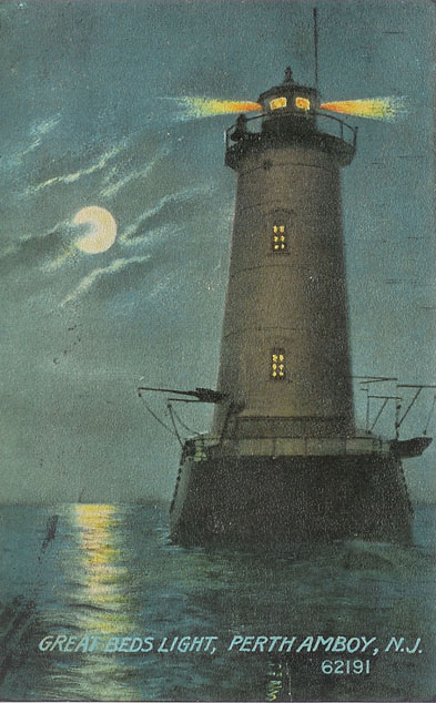
Great Beds Lighthouse Post Card Courtesy of Joyce Elyea.
There are a number of sites which have some very interesting photos of Great Beds Lighthouse:
- Gail Tanski is a Morgan based photographer and offers a number of very nice photos of Great Beds Lighthouse for sale. I particularly like the one with the gull and the sands of Raritan Bay Waterfront Park in the foreground!
- This web site has a very clear and very nice photo of the lighthouse.
- On this web site is a stunning photo taken from a January 1918 post card when Raritan Bay was so frozen over that people were able to walk (and drive) to the lighthouse! There is also a link to a local newspaper article regarding that very cold day.
- This site has a classic 1914 post card image which is also shown here, courtesy of Joyce Elyea.
- This site has aerial photos.
- This site has the same text as the USCG web site but with more photos.
Surplus Lighthouses for Sale!
Thank you to my long time school friend Ken and long ago Morgan neighbor James who at the time both sent me a link to the May 12, 2011 Asbury Park Press article (still available but a fee is now required to read the whole article, use this CBS one instead) about Raritan Bay’s Great Beds Lighthouse. I was amazed to find out at that time that, unbelievably (to me), the Great Beds Lighthouse and the Romer Shoal Lighthouse were both declared to be surplus and the federal government put them both up for auction as they could not find any organizations that would maintain them. Until I did the research on the NY/NJ Boundary Commission, I had never heard of much less seen the Romer Shoals Lighthouse. The Romer Shoals Lighthouse is located 3.4 miles north northwest of the tip of Sandy Hook. Like Great Beds, Romer Shoals is completely surrounded by water. Both play an instrumental role in the definition of the boundary line between NY and NJ. In fact the present day over the water boundaries between New York and New Jersey were defined in 1887 using the Great Beds Lighthouse and the Romer Shoal Beacon (predecessor of the Romer Shoal Lighthouse) as reference points so the state boundaries go right through them. Makes you kind of wonder to which state the new owners pay property tax to.
People interested in bidding for either lighthouse needed to contact the U.S. General Services Administration. The new owners also needed to allow the federal government periodic access to keep the navigational equipment, which they will still own, working. Specific information about both lighthouses, including contact information for potential buyers, was obtained from the US GSA Office of Real Property web site (which is no longer active for these two properties).
As of the time of the original posting of this write-up, there were no bidders listed on the US GSA website for either lighthouse. The registration deposit required was $10,000 and the minimum bid increment was $5,000. To support the sale, the US Coast Guard hosted an inspection tour of both lighthouses for the nine registered potential buyers (plus one guest each was allowed) on June 9, 2011. A videographer named Robert Sciarrino later posted a 1:58 minute video of this inspection tour. You can also see photos of the inspection by clicking HERE.

US General Services Administration’s Web Site Auctioning off the Great Beds Lighthouse in June 2011.
Great Beds Lighthouse – SOLD!
If I read the U.S. General Services Administration web site correctly, it looks like Great Beds Lighthouse was sold to someone with the identifier “homeben@” for $90,000. My Morgan neighbor Al said that he considered purchasing Great Beds Lighthouse, which he can still see from his front window, but opted not to. The bidding started on June 14, 2011 at $10,000. Bids were incremented by $5,000 and the final bid was placed on June 28, 2011. This person or group of people must have really wanted this historical building, the symbol for the City of South Amboy, as they were both the first and last bidder. Congratulations to them! I’m sure I speak for everyone when I say that I hope they will take good care of it.
I haven’t heard that this would ever happen but I hope who ever acquired these very unique properties will restore and make them available for tours. I know I would pay a reasonable amount of money to visit the Great Beds Lighthouse and have a picnic on the top patio on a beautiful summer day. That would be very cool.
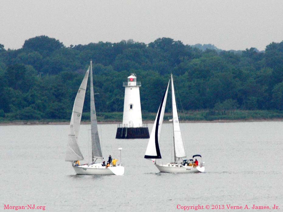
Sailboats on a Lazy Summer Day Near Great Beds Lighthouse.
Today
Some very nice action paintings featuring the Great Beds Lighthouse are on display at the Proprietary House in Perth Amboy, NJ.
Despite being over 130 years old as of the time of this writing, Great Beds Lighthouse is still a functioning lighthouse. It became fully automated in 1995. Every day it helps guide ships from around the world as they pass through Raritan Bay via the Red Bank Reach, Ward Point Bend (East & West), South Amboy Reach, and Great Beds Reach navigational channels. These channels connect the Raritan River, the Arthur Kill (Newark Bay) with the Atlantic Ocean and the rest of the world.
It has been adopted by the City of South Amboy as their symbol. On May 29, 2008, it was added to the National Park Services’ National Register of Historic Places. Every six seconds its red light is broadcast across Raritan Bay and toward all the communities bordering Raritan Bay – including Morgan, NJ.
Stats
- Position: 40° 29′ 11.9″ N, 74° 15′ 10.9″ W
- Current Owner: Private Party
- US Coast Guard Light List Number: 36430
- Construction Completed: 1880
- Year First Lit: 1880
- Dates of Operation: 1880 – present
- Operational: Yes
- Foundation Materials: Caisson
- Building Material: Cast iron and brick
- Tower Shape: Conical
- Color/Markings: White with black base
- Tower: 47 feet
- Elevation: On 14 foot tall concrete pier at sea level
- Relationship to Other Structure: Integral
- Original Lens: Fourth Order Fresnel
- Light Characteristics: Flashes Red every 6 seconds
- Focal Plane: 61 feet
- LightVisualRange: 6 Nautical Miles
- Beacon Installed: 1945
- Automated: 1995
- Sound Signal: None
- Existing Buildings: Keeper’s quarters (located within tower)
- Current Lens: 300mm
- Open to Public: No
- Waterway Location: Where the mouths of the Raritan River and Arthur Kill meet in Raritan Bay
- Significant Feature: Lighthouse was constructed to mark and preserve the large oyster
- beds located just east of South Amboy, NJ and south of Staten Island, NY
That Question from Childhood
You’re probably wondering what the childhood question was that I alluded to in the first part of this posting. The question was with regard to why did I unearth oyster shells whenever I dug anywhere in our yard, which was on a bluff some 30 feet above the water level of Raritan Bay? The partial answer was because Raritan Bay used to contain great beds of oysters. The other part, why the shells are situated 30 feet ABOVE sea level, still needs explaining.
Originally posted on November 1, 2009. Merged with others posted on May 22, June 30 & August 5, 2011.
My Grandfather George Washington Denton Jr. was the lighthouse keeper at the time of the Morgan Explosion and fires. He stayed at his post all through the night and the next day. The lighthouse was damaged and he helped with the damage repairs.