Morgan Memories – Oyster Shells in my Front Yard
It always seemed to happen. Dig even just a little bit at our house in the yard facing the bay and you would inevitably hit oyster shells – and not just a few of them. This always perplexed me as the yard was about forty feet above sea level. Though I never heard the phrase when I grew up there, starting in the 1800s (or so) this bluff used to be referenced in documents as “Morgan Heights” or after the railroad went in, as “Morgan Station.” Previously, and for nearly 200 years, it had been part of the Morgan family’s estate.
It was what likely happened before that time which might explain why there were gobs of oyster shells some 40 feet above the bay. Last I heard, oysters didn’t grow on trees. At the time, I thought perhaps the land must have slowly risen over the prior million or so years. Afterall, tectonic plate movement explains how mountains are made.
My mother had a different suggestion. She said it was due to the Lenni Lenape who lived there for millennia before the Europeans settled what we now know as New Jersey. Franky, at the time I thought she was a tad nuts. The tectonic plate movement theory was the more likely answer in my much younger mind.
Fast forward to too many years more than I like for it to have been. After performing tons of research over the years, I inadvertently stumbled over some interesting old historical documents which discuss this very topic. Turns out, my Mom’s answer seems to be the correct one based on these documents I recently found. We’ll also get a brief history lesson regarding the native peoples who occupied Morgan before it was Morgan.
The following is from the January 1924 PROCEEDINGS OF THE NEW JERSEY HISTORICAL SOCIETY, The Aboriginal Inhabitants of Monmouth County by Prof. Charles A. Philhower. It discusses the Unami, who were the Lenni Lenape people who lived around Raritan Bay.
The Lenni Lenape occupied mainly the Delaware River Val-
ley. All of what is now New Jersey belonged to them…
The name Lenni Lenape signifies original people. Lenni, in
the Delaware language, used as an adjective, means “original,
pure.” “Len” means our, and “ape,” man, which, interpreted,
is “original of our people.”…
There were three sub-division of the Lenni Lenape, the
Unami, the Wunalachtikos, and the Monsis, according to Los-
kiel. The Unami took the lead in civil affairs and occupied the
central part of the State, south of the Musconetcong and the
Raritan, to the Asseroches (Copper Creek) at Camden on the
Delaware and the Mullica River on the coast…
The name Unami was variously pronounced by the French,
English and Dutch. Some of the written interpretations of the
oral word as heard from the mouths of the Indians are:
Unamines, Unamin, Wanami, Wenanmeew, Wonami, Wuman-
meeh, Wonameyo and Wenanmeiw. The word signifies “The
People down the River.” They always held precedence in
civic affairs over the other Delawares, and were often spoken
of as the Turtle Tribe. Their totemic emblem was the turtle,
called by them “pokoango,” the crawler. There were probably
two council fires, one near Trenton at Crossweeksung and the
other possibly at Warmesing (Morgan), on the Raritan Bay
at Cheesequake Creek (Chesnaquack)…
The Indian name for New Jersey was Scheyichbi, or Sche-
Jachbi (pronounced Scha-ak-bee). It means long, land water,
which is significant of the land lying between the Hudson and
Atlantic on one side and the Delaware on the other. The In-
dian name for the Delaware was Lenape Wihittuck. The name
of the Hudson was Mahicanituk, and that part of the Atlantic sea-
board, Seawanhacky, or place of shells…
The numerous shell heaps found along the coast of Monmouth county,
[the boarder of which is located 3 miles east of Cheesequake Creek]
and the size of many of them,
attest to the fact that thousands of Indians repaired to these
quarters, where they gathered shells for wampum, seawan,
peague, or roanoke, and stored up quantities of dried fish,
oysters and clams. As late as 1820 Indians were observed
journeying over the Minisink Trail to the land of Seawan-
hackey at Navesink [They would have crossed near or through the
Morgan Estate]…
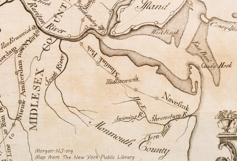
A great village frequently referred to and variously spelled
was located at Morgan at the mouth of Chesnaquack Creek
(Cheesequake) on the northwest side. As nearly as I can de-
termine this was the village of Wromasang, Weomasing, or
Ramesing…
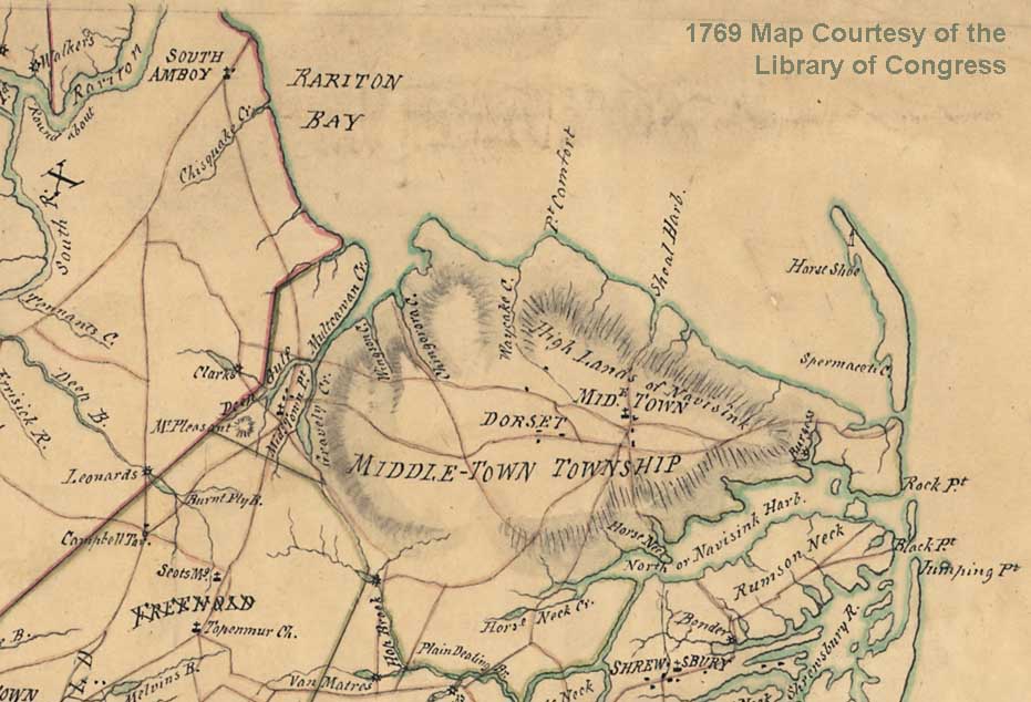
The above identifies the location of my childhood home, “… Morgan at the mouth of [Cheesequake Creek] on the northwest side.” Before its reshaping into the present-day channel in 1883, the original mouth of Cheesequake Creek was located parallel to the railroad tracks where NJ State Highway 35’s northbound trestle bridge is presently located.
… The Great Minisink Trail crossed the Raritan at
Sayreville
at the neck of land in early times known as Kents’ Neck, just
west of Crab Island. Motochshegan’s Camp was on the north
shore at this point back of the marsh. The Trail paralleled
the coast along the Bay from Sayreville [through Morgan] to Matawan. Here it
passed the village of Matawan, the seat of the Matovancons,
and crossed the tract known as Mowhingsunge, lying between
Matawan Creek and Mowhingshunge Creek. From thence it
passed over Indian Hill equally distant from the shore, and
thence through the village of Chawcosett at Middletown. With
a curve to the southward it swung into Navesink. Near Fair-
view it met the Crossweeksung Trail…
While the Indians had special places where they buried the
dead many times, especially in winter, they were buried, if in-
terred at all, on the immediate camp site, sometimes beneath
the wickon, or wigwam. Consequently, in proportion to the
number of Indians there were in the State we find few burial
sites as such. I have found burials in Monmouth in the shell
heaps, and on village sites. This is not unusual. There were
burial sites near Sayreville, at the crossing of the Minisink
Trail, at Morgan, at Indian Hill and at Crosswicksung…
The following is also from the same author in the January 1924 PROCEEDINGS OF THE NEW JERSEY HISTORICAL SOCIETY but in a different section, The Minisink Indian Trail by Professor Charles F. Philhower:
… The trail went on from Sayreville to Morgan, where it
crossed the Cheesequake Creek (Indian, Ches-na-quack). There
was a great council fire. The course was thence to Matawan,
Wickatunk and south of Swimming river to Shrewsberry and
Navisink rivers…
Probably the main purpose of this Trail was for
frequenting
the shell fisheries of the coast.
Oysters, clams, scallops, whelks,
sea snails, muscles, crabs and fish were highly relished by the
Indians. The many shell heaps of
Monmouth county about
the mouth of the Raritan, and Shrewsbury Inlet are evidence
of the extensive use of sea foods. Shell
heaps forty to sixty
feet in diameter and ten feet deep are not uncommon. In these
heaps are found ash beds, fragments of pottery, stone imple-
ments and animal bones. In some heaps bone
awls are not
unusual. This indicates that such
locality was a drying station,
and the awls were used for stringing the dried product, which
was transported to their mountain fastnesses.
Fish were also
dried for later use. Drying was the most
common means of
preserving food. It is not uncommon to find
burials beneath
shell heaps.
Not sure if this is true or not but I had heard sometime around 2008 that construction of one of the homes on Cliff Avenue, north of North Street, was delayed because of the discovery of buried human remains. If true, the human remains might have been of one of the aboriginal people, one of the Morgan family slaves, or perhaps Jimmy Hoffa.
This section is from the earlier 1913 publication, “A Preliminary Report of the Archaeological Survey of the State of New Jersey…”
Shell heaps. — Shell heaps frequently mark the garbage dump of some old Indian village. They often occur near the sites of former settlements, always near water, and sometimes by themselves, far out on the salt meadows. Those on the marshes present the shell mound in its most typical form, and mark the spot where the Indian procured and dried oysters and other bivalves to carry inland for consumption. Often these heaps are of great size, like the mound at Tuckerton, and frequently they contain nothing but shells from top to bottom. Relics are never so abundant in any shell heap as they are on a village site, and often a search of the fields nearby will prove more productive than digging in the mound.
The shell heaps on the mainland are often not heaps at all, in the true sense of the word, although they may have been several feet above the surface in Indian times. The washing of earth or the blowing of sand has covered them with many inches of concealing soil, and they may only be found through the chance burrowing of some animal which throws out the shells, or the passage of a ploughshare through their midst. These mainland heaps are most apt to be true kitchen middens, and in them may often be found many of the objects that occur on village sites, and, as in the firepits, objects that would otherwise decay are preserved by the protecting soil and shells. Beneath the shell heap are often found the skeletons of the Indians themselves, perhaps interred there for concealment from foes, or for some reason unknown to-day. Fire pits and refuse holes are also found uncles the shell layers.
These images are from page 45 of the report and provide pretty conclusive findings my late mother would agree with. BTW, the numbers in the parenthesis, e.g., (28-I-3-I-I, 5.), are indications of where to look on specific topographical maps such as this one or this one (see the detailed instructions starting on page 13 of this document).
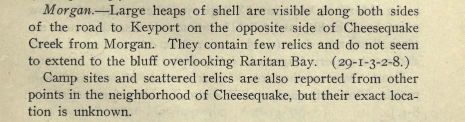
I think “… road to Keyport on the opposite side of Cheesequake Creek from Morgan…” essentially means the land under present day Route 35 on the south side of Cheesequake Creek and “… the bluff overlooking Raritan Bay…” is the bluff of present day Lawrence Harbor where Shoreland Circle is located.
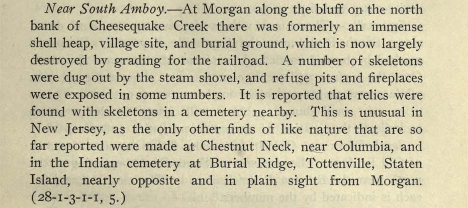
And there you have it! “At Morgan along the bluff on the north bank of Cheesequake Creek there was formerly an immense shell heap…” Boom!
I lived in Laurece Harbor from 1972 to 2016 . Originally from Rahway so named i believe for an Indian chief named Rawack . My Harbor home was on the bluff overlooking the marshes looking towards Cheesequake Creek . I had fished crabbed duck hunted most of that area . I would find many oyster shells in the area including walks in Cheesequake Park . Easy to see why the Lenape like the area . Plentiful food . From my research i learned the Cheesequake creek area was claimed by the munsee sect of the Lenape their sway went up to where i now live in northeast pa wayne county . The minisink trail was the main route from jersey shore areas to the mountains and upper Delaware River . Parts of the trail actually go from Tuckerton where family had a summer home where i saw the big mounds of shells there as well as behind the keyport fishery in Keyport . The terminus of this trail according to some is near indian orchard pa just south of Honesdale my new county seat . I always found the story of the Lenape fascinating as their contact and its results with my European forbears.