Morgan Maps – The New York / New Jersey Boundary on Raritan Bay
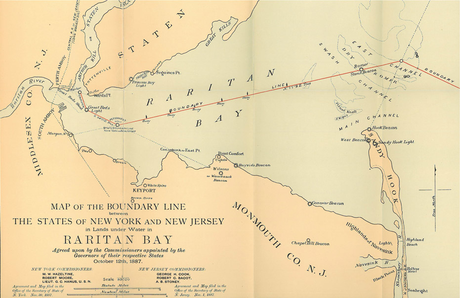
“Map of the Boundary Line between the States of New York and New Jersey in Lands under Water in Raritan Bay” from the 1887 Joint Boundary Commission Report.
If you look at the “Map of the Boundary Line between the States of New York and New Jersey in Lands under Water in Raritan Bay” from the Joint Boundary Commission Report dated October 12, 1887, you’ll see that there are four Raritan Bay boundary line segments making up the boundary. These points and boundary lines were agreed to by the members of the commission at their ninth meeting held on September 21, 1887 at 47 Montgomery Street in Jersey City, NJ.
Starting with the segment at the mouth of the Arthur Kill and ending with the segment just north of Sandy Hook which projects out into the Atlantic Ocean, this posting will discuss what was used to determine the start and end points for each of the four line segments. Some points were based on structures which were present at the time either on land or in the bay. Some of these structures are still there, others are not. Some of the points were derived by using landmarks visible from the bay to create a point over the bay. At the time of the report in 1887, two of the structures were present in the bay, one structure was to be placed in the bay, one point was “Morgan 2” (see the to-be-reposted Morgan-NJ.org page about “Morgan 2”), and five of the landmarks were physical structures.
Some of the text in the following descriptions is from the Joint Boundary Report which was subsequently translated into state law. I’ve made some changes to the verbiage to make it easier to read (at least for me).
First Boundary Line Segment
The first point in this line segment is a point over the bay which was derived by using two buildings as a reference. The second point in this line segment is the Great Beds Lighthouse which is featured in this Morgan-NJ.org page.
For the first point, one building was (and maybe still is) in Perth Amboy, NJ. The other building was (and maybe still is) at Ward’s Point on Staten Island, NY. The point derived from these two buildings was “equidistant between the southwesterly corner of the dwelling-house of David C. Butler at Ward’s Point on Staten Island in the state of New York and the southeasterly corner of the brick building on the lands of Cortlandt L. Parker at the intersection of the westerly line of Water street with the northerly line of Lewis Street in Perth Amboy in the state of New Jersey.”
The line going between the derived bisection point and Great Beds Lighthouse goes in the direction of 159 degrees 44 minutes off of true north.
Second Boundary Line Segment
The second line segment started at Great Beds Lighthouse and ended at a point which was at the intersection of two lines.
The first line of the intersection went from Great Beds Lighthouse to a 96 foot tall beacon, completed in 1856, located in what is now Keansburg (Monmouth County), New Jersey. The beacon was the Waackaack Rear Range Light (notated on the map as “Wilson’s or Waackaack Beacon”) which was on land acquired from a person named Andrew Wilson. Surveyors would easily be able to see both of these structures from the bay. Unfortunately the Waackaack Rear Range Light was torn down in the 1950’s. The area is now a residential neighborhood.
Incidentally, the line going between the Great Beds Lighthouse and Waackaack Rear Range Light goes in the direction of 115 degrees 39 minutes off of true north.
The second line of the intersection starts on the west side of the bay at a point called “Morgan 2” then cuts straight across the bay to a point in the bay just north of Sandy Hook known as the “Romer Stone Beacon”. It took me a very long time to piece it together but “Morgan 2” is/was a “Triangulation Point” defined/created by the U. S. Coast and Geodetic Survey (predecessor to the current National Oceanic and Atmospheric Administration’s National Geodetic Survey) sometime during or before 1834. See the to-be-reposted Morgan-NJ.org page which discusses “Morgan 2” in more depth. This particular survey point has a very important and key characteristic. If you think of Raritan Bay as a big angle with the north side being New York and the south side being New Jersey – easily pictured if you view the photos from space contained in this Morgan-NJ.org page – “Morgan 2” lies at the vertex of the angle. The easiest way to partition the bay between the two states is to divide this angle in half. From that line south is New Jersey. From that line north is New York. That is essentially what was done by the 1877 Joint Boundary Commission.
The second point defining this line which intersects with the Great Beds Light/Waackaack Beacon line is/was the “Granite and Iron beacon” situated on the “Dry Romer shoal”. Construction for this beacon started in 1885 and continued into 1886 when, on July 15th, the light was turned on for the first time. Today there is a 54-foot tall “sparkplug” lighthouse (the same type of light house as Great Beds Lighthouse) which was installed in 1898. I never knew there was a lighthouse here and look forward to seeing it in on a future trip to NJ. You can learn more about the Romer Shoal Lighthouse by clicking here.
At this intersection point a permanent “monument” was eventually placed. This is identified on the map as “Permanent Mont.” See the Morgan-NJ.org page about “The Monument” for more information.
Third Boundary Line Segment
The third boundary line occupies most of the “Morgan 2”/Romer line discussed in the Second Boundary Line Segment section above. This boundary line, the longest straight line boundary segment on RaritanBay at nearly 14 statue miles in length, has the most significance to Morgan as this line uses the “Morgan 2” triangulation point as one of its two defining points. Though “Morgan 2” marks the beginning of the line, the boundary actually starts at the Monument, located a little further to the east. This boundary line lies 77 degrees 9 minutes from true north and extends through the Romer Stone Beacon (Lighthouse) further east until it intersects yet another virtual line. Between the Monument and the Romer Stone Beacon were to be placed, per the Joint Boundary Commission Report, “eight buoys or spindles.”
There is more to the story regarding what lies on this line when projected further west of “Morgan 2”. See the Morgan-NJ.org page about the “Rocket Launcher”.
The line which intersects this third boundary line essentially is the dividing line between RaritanBay and the Atlantic Ocean. Its first point, located on the south side of the bay, uses a beacon which was, and maybe still is, located on the northern tip of the Sandy Hook, NJ peninsula. The second point, located on the northern part of the bay, was the Oriental Hotel on Coney Island. Opened by Andrew Culver in 1876, the Oriental Hotel was the most exclusive of the three exclusive and plush big name hotels which catered to the well to do during Coney Island’s heyday. Though long gone, having closed in 1916, today the site of the Oriental Hotel is occupied by Manhattan BeachPark.
Fourth Boundary Line Segment
At the intersection of the “Morgan 2”/Romer line and the Sandy Hook Beacon/Oriental Hotel line is the point where the fourth boundary line segment starts and heads at a right angle in a more southerly direction into the Atlantic Ocean.
First posted on March 21, 2010.
The Perth Amboy brick building owned by Cortlandt L. Parker mentioned in the following passage was probably the “Parker Castle,” a large masonry structure, or one of its outbuildings. The location “fits.” Parker Castle was demolished long ago.
“equidistant between the southwesterly corner of the dwelling-house of David C. Butler at Ward’s Point on Staten Island in the state of New York and the southeasterly corner of the brick building on the lands of Cortlandt L. Parker at the intersection of the westerly line of Water street with the northerly line of Lewis Street in Perth Amboy in the state of New Jersey.”
It goes without saying that destroying, damaging, or displacing any survey marker is a deplorable act. In the case of a U.S. Geological Survey or U.S. Coast and Geodetic Survey marker or monument, it is also a criminal act.
It’s unpleasant to think that the loss of the Morgan No. 2 marker and the Parker Castle has cast a pall of uncertainty over the exact location of the boundary between NY and NJ with regard to Raritan Bay.