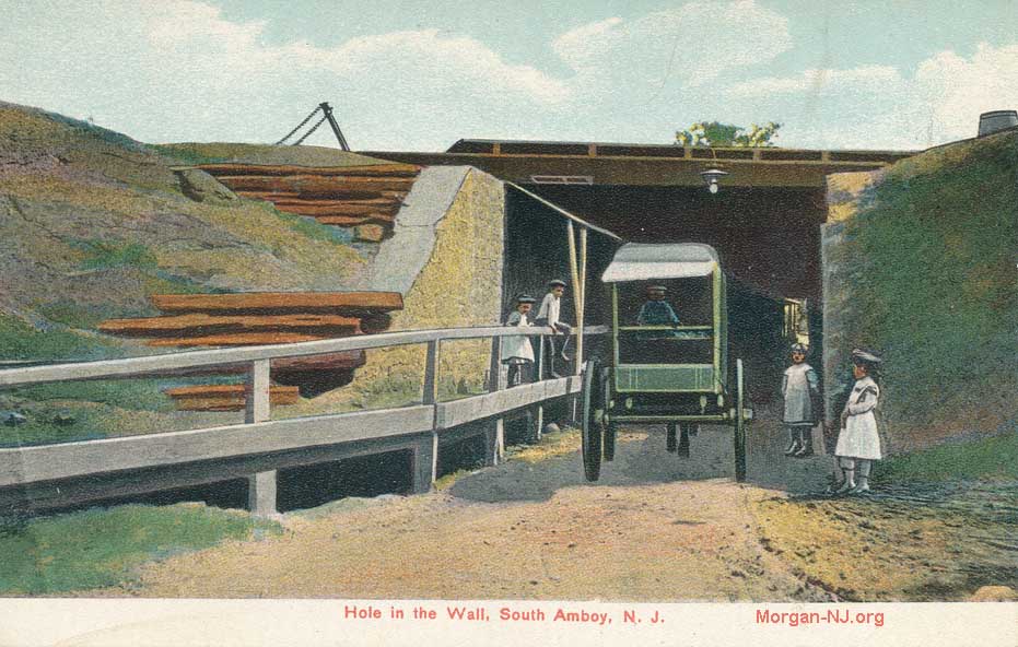
Anyone growing up in or near South Amboy, NJ for well more than the last 100 years most likely had either heard of the “Hole-in-the-Wall” or had actually driven through it.
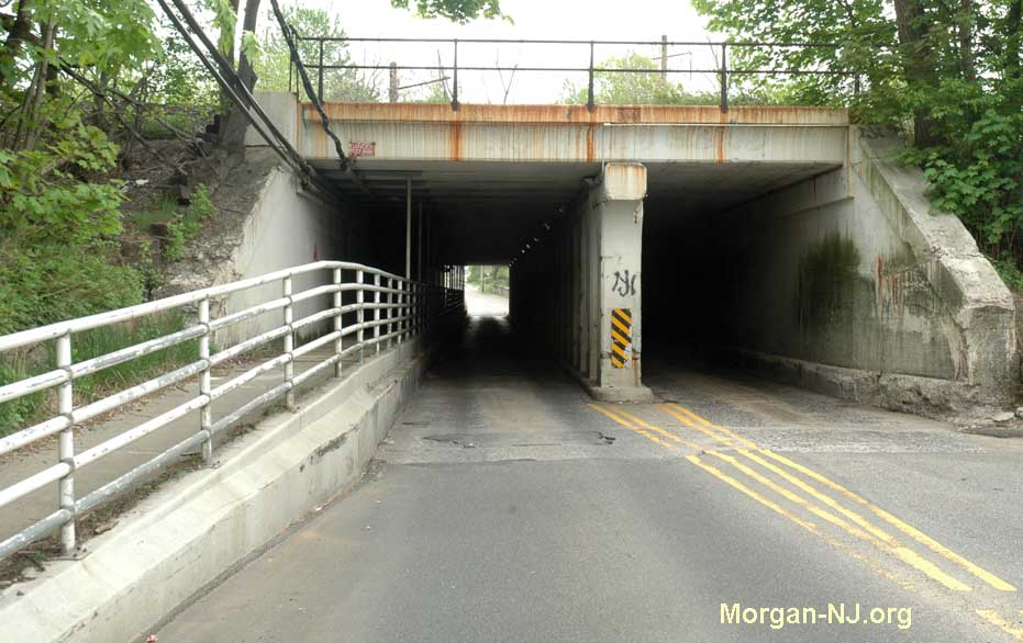
For everyone else, the “Hole-in-the-Wall” is an ancient road tunnel located just north of the Rollermagic skating rink on Ridgeway Avenue/North Stevens Avenue. Ridgeway Avenue isn’t a main street – anymore, more on that later – but it is still the most direct way to go from Main Street, South Amboy to the Mechanicsville section of South Amboy and to the neighboring Melrose section of Sayreville.
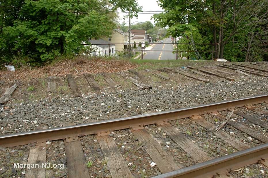
Never having really having thought about it when I grew up in Morgan, it wasn’t until a visit decades after I moved out of Morgan that I finally climbed up on top of the Hole-in-the-Wall to determine just what the darn thing was all about.
This is what I saw. Afterward, many things then started making sense to me.
For a long time, I had put off writing anything about the Hole-in-the-Wall as I didn’t really have much to offer about it. Recently, however, while doing research for the “County Bridge” (hopefully to be posted in the near future), I came to learn more about it which I thought readers might find interesting.
It all starts, I think, with the Camden and Amboy (C&A) Railroad. The C&A was the first chartered railroad in the US, the first railroad opened in New Jersey (think about that, a world before railroads), and one of the first ones in the United States. In fact, it is actually one of the first railroads in the world. Seeing the John Bull locomotive, the first locomotive to run regular operations on the C&A starting on September 9, 1833, at the Smithsonian in Washington, DC served as the catalyst for creating this web site.
Created – then run – through the efforts of the Stevens Family (à la Stevens Avenue and Stevens Institute of Technology), the railroad initially connected South Amboy with Bordentown when it first opened in 1831. A year later, the road was completed when it extended all the way down to Camden. At that time, South Amboy was not very developed and, correspondingly, sparsely populated. Its main characteristic needed for the railroad was being a port located on the south side of the seemingly unsurmountable Raritan River. Bridge technology was nascent at that time. Choosing a route that didn’t cross a major river allowed for no major bridges to have to have been constructed. The first bridge of any type to connect South Amboy and Perth Amboy across the mouth of the wide Raritan River opened some 45 years later in 1876.
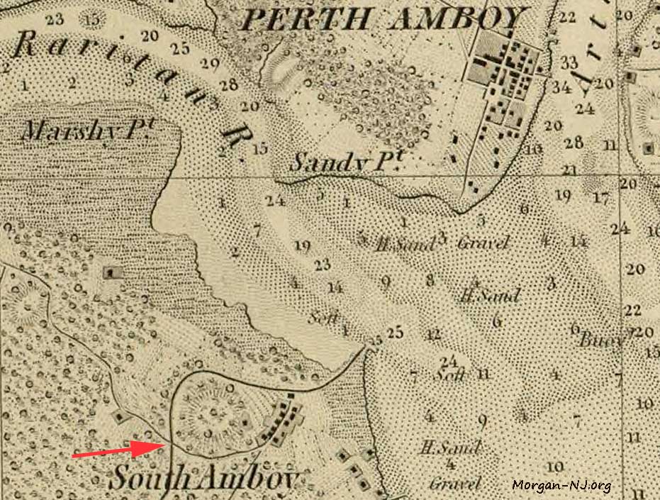
Per the really old maps of the day, most of the buildings in South Amboy were for the railroad and were located in the area near present-day Main Street around Broadway. The focus of the hamlet was the dock area, where a ferry was or had been located, and the ancient road, now named Main Street, which lead southwest to Cranbury and beyond. The grid of South Amboy as we know it today didn’t come about until John Perrine, Jr. surveyed the area in June 1835. In other words, there weren’t too many people in South Amboy, and the necessity to cross the railroad to get to the river – either by foot, horse or wagon – wasn’t generally very high.
Here is the earliest map I’ve found thus far showing a road crossing the C&A tracks at the location of the Hole-in-the-Wall. It is from 1845, just under 15 years after the initial single track was laid in 1831. On this map can be seen the sparce population at the time.
Much of the early history of this intersection is detailed in the first issue of the South Amboy Citizen which is available on the Sadie Pope Dowdell Library web site. The July 2, 1910 article, which begins on page 1, column 5, indicates:
In the year of 1832, in the earliest days of railroad building in this country and the world, the Camden and Amboy Railroad Company first built its railroad, and laid down the rails of its tracks at the place in controversy. They built it across an old road, or drift way, which has since grown into Ridgeway Avenue. This old road in 1832, was merely a single track wagon way, used by the public in driving horses and wagons over the railroad track, and remained the same width and condition until the year 1857 — a period of 25 years — when the defendants, acting, doubtlessly, for their own interests as well as for those of the public, widened its limits by constructing at right angles with the road, two stone wall abutments, 14 feet apart, and then elevating and placing their railroad tracks upon the top of the abutment walls, sufficiently high and wide above the wagon road to permit the passage of carriages, horses and cattle over it, and under the railroad, in conformity to law and charter provisions. The effect of this change of 1857 was to widen the highway there from a single wagon track crossing at grade, of about 7 feet in width to an undergrade crossing of 14 feet in width. The devotion in 1857 by the defendants of this increased width of land, for the purposes of the crossing, must be presumed, as against them, to have been a dedication by them of their land to and for the use of the public. It has remained unchanged ever since, and up to the time of the entry of the decree below.
No record or other return in writing if the laying out of the old road, nor any applicable to it, appears in the evidence, but the bill of complaint avers that this Ridgeway Avenue or highway, was originally laid out to a width of fifty feet, and charges that the abutments encroach upon the highway, and asks that they be changed to the proper line of the street, and the roadway between them be widened accordingly. Its specific prayer (which I deem important to transcribe here) is that “the Pennsylvania Railroad Company and the United New Jersey and Canal Company may answer the premises, and may be compelled specifically to perform the duties imposed by law upon them, or either of them, with respect to the construction, main tenance and repair of the crossing of Ridgeway Avenue, or Stevens Avenue, in the borough of South Amboy by their tracks, and that your Honor will prescribe the crossing be constructed and the repairs to made, and that they may be required to remove the abutments placed by them within the lines of the highway aforesaid, and to properly improve said highway to the full width thereof and make the necessary provisions for the carrying away of surface water and drainage and sand and soil now washed upon said highway beneath said tracks.”…
… “that the defendant shall, within six months from its entry, separate the walls now constructed under the tracks of the defendant companies at the place set forth and prescribed in the bill of complaint in this cause so as to leave thirty-three feet in the clear between said walls, said width being deemed by the Court at this time adequate for public travel on said highway. Provided, however, that the defendants shall have the right to erect supports or columns through said passage way to occupy at the base thereof a space not greater than two feet in width, and to so erect the same as that shall be a roadway of not less than twelve and one-half feet on the northerly side of said passage way, and of not less than twelve and one-halt feet and a sidewalk of six feet on the southerly side of said passage way.” …
Adoption of usage of the automobile, though still early, was well underway by 1910. The Hole-in-the-Wall, as narrow as it was at the time, was part of the main route used by motorists as they worked their way south from areas such as Newark, through Perth Amboy, South Amboy, and Morgan on their way to points south – such as perhaps the Jersey Shore.
This map is from the 1910 Automobile Blue Book, the forerunner to the American Automobile Association and GPS navigation.
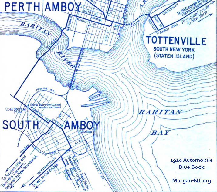
Here is the route corresponding to the above map for the portion going through the Hole-in-the-Wall (“… dark, narrow RR, tunnel…”) from Perth Amboy through South Amboy and Morgan:
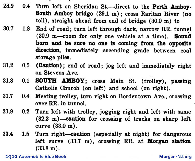
We see in that 1910 map that the current route east on Main Street which turns left and runs on the south side of the Raritan River was not yet constructed. This one-lane tunnel in the Hole-in-the-Wall generated decades of close calls, at least one death, and a lot of excitement for teenage new drivers.
Here is another article from the South Amboy Citizen, dated July 18, 1914 (page 16 – STUBBORN AUTOMOBILISTS SCRAP AT HOLE-IN-THE-WALL), it describes the tense standoff between two drivers who came from opposite ends of that “room for only one vehicle at a time” tunnel and met in the middle with neither wanting to or able to back up.
As of November 1918, there were something like eight (8) munitions plants located in next door Sayreville supplying the Allied forces in Europe (World War I). The biggest one, the Morgan based T. A. Gillespie Loading Company, just weeks earlier in early October had a series of catastrophic explosions that essentially destroyed it. Due to its importance to the war effort, expedited actions were already underway by the US government to rebuild the plant in order to continue supplying the much-needed artillery shells, mortars, etc. to the Allied Expeditionary Forces in Europe.
Trucks to/from Gillespie utilizing the County Bridge over the Raritan River had to cross the C & A’s tracks somewhere. This meant either through the Hole-in-the-Wall or closer to the river on the section of the road apparently known then as “the Pennsylvania cut out”. This road, which doesn’t show on the 1910 map, above was most likely corresponds to today’s portion of Main Street which crosses under the railroad tracks and the new Radford Ferry Road bridge. This November 2, 1918 South Amboy Citizen page 1 article discusses limitations to truck movements at the Hole-in-the-Wall.
TRYING TO SOLVE THE ROAD PROBLEM
After dodging the “Hole-in-the-wall” proposition for a number of years the authorities of this city, Middlesex county and the State Highway Commission are now face to face with a question that needs immediate attention. The T. A. Gillespie Construction Company declares that unless proper roads to and from their plant are provided the construction work will have to cease. The huge trucks that are employed to carry material to the plant cannot navigate over the roads that now exist. The matter now ceases to be a political issue and it becomes a war time necessity to act…… After some discussion the thought of repairing the “Hole-in-the-Wall” road was abandoned on account of the “hole.” The only other outlet is through the Pennsylvania cut out as it is termed. Means of financing the reconstruction work was discussed and it was finally decided to leave this to the committee at a meeting to be held at Washington either Saturday or Monday…
No one knew that 9 days after this newspaper article was published, the war would come to a seemingly abruptly close.
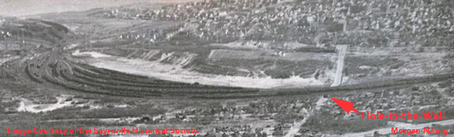
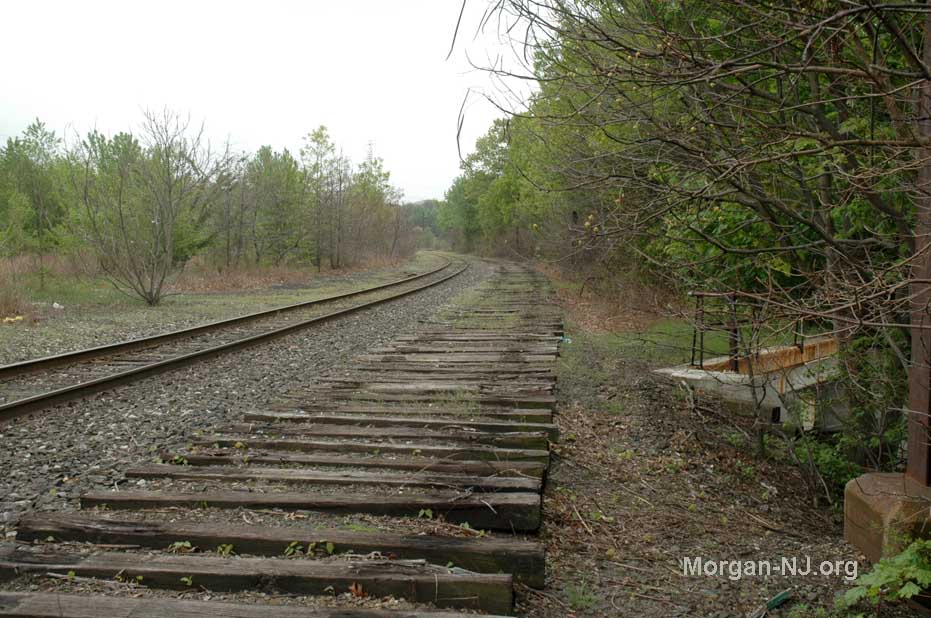
Sometime in the mid to late1800s, for a period perhaps approaching 100 years, there was an entire freight yard of tracks which was used to hold carloads of anthracite coal from Pennsylvania to be loaded onto barges or “lighters” for shipments along the east coast, often or typically, New York City. There were also periods of time when munitions were stored in cars in that yard as evidenced by the Power Pier explosion of May 19, 1950, where 450 tons of munitions being loaded on lighters at the port of South Amboy exploded killing 31 people and injuring over 350 more.
Somewhere I had once seen an image of a trolley going through the Hole-in-the-Wall but, naturally, I can’t find that image now. Can you imagine trying to juggle wagons, cars, trucks and trolleys through that opening in the early part of the 20th-century?
Readers interested in seeing a very nice 1940 aerial view of South Amboy with the tracks above the Hole-in-the-Wall full of railroad coal hopper cars can travel back in time via the Historic Aerials web site by performing the following steps:
- Open a browser on your computer such as Chrome, Safari, etc.
- Go to “historicaerials.com/viewer”
- In the section which says “geo coordinates or street address”, type in “500 Ridgeway Avenue, South Amboy, NJ”
- Click “go”
- Click “aerials”
- Click on “1940”
In the Historic Aerials’ 1940 image, you’ll see at least 8 rows of railroad tracks full of coal hopper cars. Looking at later years on Historic Aerials, it seems that coal usage peaked sometime in the 1940s. No doubt it was a very busy time around and above the Hole-in-the-Wall during World War II. Aerial images of more recent years of the area above the Hole-in-the-Wall, as well as my images here, show nature reclaiming the area as evidenced by the growth of many trees where there once were railroad tracks.
We know from the 1910 article and the 1914 article that the Hole-in-the-Wall tunnel was only one lane wide with a pedestrian section. I haven’t found information yet indicating when it was widened to its present two lanes with a pedestrian section but we do know it had two lanes by sometime in 1927. Page 10 of the July 7, 2015 South Amboy – Sayreville Times (also available on South Amboy’s Sadie Pope Dowdell Public Library’s web site) has a 1927 image of the “Hole-in-the-Wall” with railroad coal cars on top and a car coming out of it. Today’s Hole-in-the-Wall doesn’t seem all that much different from the 1927 image.
Here is a YouTube video of the “Hole-in-the-Wall”.
If anyone finds definitive information about when the extra tunnel was added, please let us know. Hopefully, and because of its location in a not heavily traversed road, this artifact of past years will remain unchanged and unique for at least another 100 years.
Here are a number of other articles from early issues of the South Amboy Citizen which mention the “Hole-in-the-Wall”:
ON WATCH FOR LAMP BREAKER.
Complaints about mischievous boys breaking lamps under the Hole in the Wall have been received. It is said to be a common thing for those in authority to replace lamps daily. A close watch is to be kept on children and others suspected of being responsible and if caught they will be severely punished for the action.
AGED WOMAN WALKING THROUGH HOLE-IN-THE-WALL HIT BY AUTO: DIES OF INJURY
People in this section of the city are anxiously awaiting some action by the Board of Freeholders or the city authorities with regard to making a sidewalk to and from the Hole-in-the-Wall, with railing if possible. Knowing the danger of children being left to their own resources on this much-frequented roadway, many parents take their children to and from the schools. This is a necessary improvement and should be done at once, people in this section claim. At the present time there is no sidewalk, and the children are forced to use the roadway.
May 13, 1927 (Page 11, Column 1)
LOOKING BACK 25 YEARS to May 17, 1902
WANT OVERHEAD BRIDGE
For many years the people of Mechanicsville have been troubled, inconvenienced and disheartened by the hole in the ground under the railroad through which they have to pass in order to get to or from business portions of the borough. They have prayed for relief, but their prayers have been without result. Every Council since the borough has been organized has attempted to assist the people in their demands, but accomplished nothing. The railroad claims that to make the hole a proper passageway would be too expensive, and every appeal has been thrust aside. Now some of the residents of this locality are circulating a petition, which has already been signed by many property holders, asking that the company erect an overhead bridge to run from Feltus street to Railroad avenue. A committee will wait on the officials shortly and submit their petition.
Naturally Mechanicsville is an excellent place for homes, as it is healthy, the land is high ground, and some fine views can be obtained from the hilltops, and the only reason it is not more built up is the abominable hole under the railroad. Even with this drawback this section of the borough continues to grow, and is extending into Sayreville township adjoining. On what used to be Fouratt Apple orchard may be seen a fine row of houses that would be a credit to any locality. A little beyond is Melrose, and it is surprising to see the many comfortable houses erected there. Give this section a good outlet over or under the Amboy Divisions tracks and its growth would be marvelous.
COUNTY BOARD PLANS RETAINING WALL AT HOLE IN WALL TO HOLD BACK SAND
Director Dey Introduces Resolution At Meeting Yesterday Authorizing Plans & Specifications: Also Begin Storm Sewer To River—A Four Year Job.
Director William S. Dey, of the Board of Freeholders, took steps yesterday afternoon at
a meeting of the County Board in New Brunswick, to relieve conditions at the hole-in-the-Wall such as occurred on Saturday night during the heavy thunder storm. A resolution was introduced and unanimously passed by the Board directing the County Engineer to prepare plans and specifications for the construction of a retaining wall along the road leading to the “hole.” The removal of sand following this storm is said to have cost in the neighborhood of one thousand dollars, and Director Dey in addressing the body yesterday spoke of the necessity of building a retaining wall to relieve this very bad condition which happens several times during the course of each year.
That this wall will be erected without delay, evinced by the fact that a meeting of the Director and the County Engineer will be held this afternoon on the site to arrange for the drawing of the plans.
The resolution reads as follows:
“Resolved, that the County Engineer be authorized and directed to prepare plans and specifications for the construction of a retaining wall along the Mechanicsville South Amboy road near the so-called Hole-in-the-Wall, and submit the same to this Board for its approval or rejection.”
Another move to remedy conditions in the neighborhood of the “Hole in the Wall” was introduced by Director Dey, to take care of the surface water coming down Ridgeway avenue. This resolution provides for the building of a ditch through Eulner street, and the installation of a pipe culvert from Ridgeway avenue to the Raritan Bay. It also provides that only one hundred feet of this culvert will be built this year and the balance of the work to be spread over a period of four years; also the entering into a contract with Chas. L. Steuerwald, Inc., for the securing of permission to run the culvert through property -belonging to this concern.
The resolution follows: “Whereas, the surface water on Ridgeway avenue has no adequate outlet, and as a result has created and is creating a dangerous traffic congestion, necessitating relief, and
“Whereas, this Board is desirous of authorizing the Engineer to prepare plans and specifications to take care of this situation, therefore:
“Be it resolved, that the County Engineer be authorized and directed to prepare plans and specifications for the construction of a ditch through Eulner street, and the installation of a pipe culvert from Ridgeway avenue to the Raritan Bay, it being understood that the work is to be so divided so as to only construct one hundred feet of this culvert this year and the balance of the work to be spread over a period of four years, said plans to be submitted to this Board for its approval or rejection, and Be It Further Resolved that the proper officers of this Board be authorized to enter into contract with the Chas. L. Stuerwald, Inc., securing permission and consent so to do and agreeing to continue this work until its completion as herein outlined.”
CAR STRIKES PILLARS IN HOLE IN THE WALL
Passengers in a Marathon bus, driven by Willard Alcott, of Second St., witnessed three young men’s very narrow escape from serious injury shortly before noon on Tuesday. The young men were riding in a small car of the racer type, and were about midway through the Hole-in-the Wall, when the car suddenly swerved into the pillars throwing the three occupants from the car.
Those in the bus were convinced that something serious had happened, and were about to investigate, when the three scrambled to their feet, and were able to push their car through the rest of the passageway. The car carried an Essex county license plate.
MECHANICSVILLE
In all probability this section of the city suffered most as the result of the storm over the week end. Hundreds of tons of sand was washed into the Hole in the Wall and on Ridgeway avenue, making traffic during the storm and until Monday evening impassable.
Director Dey’s county force of men and trucks, with the assistance of a road scraper and a digger, worked continuously removing the surplus sand.
The pitch used to calk the seams of the huge cement slabs over the Hole-in-the-Wall, is again dropping out of place. This method of sealing the slabs does not seem to be practical, as from time to time it has been necessary to recalk the seams.
The sewer pipe leading through the Hole in the Wall was broken yesterday and water in the “Hole” was about one foot deep during the day.
STATE HIGHWAY IS SAND BLOCKED
Heavy Showers Saturday Nights Fills Underpass Again.
This city and vicinity was greeted with the heaviest shower of the season last Saturday evening when it came down in torrents.
Little damage was done to local streets, and the John street storm sewer was given its best test since it was constructed and it took care of the rushing waters from the upper sections of the city.
The new work at the Pennsylvania underpass did not come up to expectations and sand washed down into new driveway to a depth of two or more, making traffic impossible. Motorists were forced to use the old driveway, one line of cars going in each direction and in some cases being held up for long periods due to stalled motors and other trouble. Two cars which had stopped under the new driveway to await the end of the shower were caught by the rush of the sand and had to be shoveled out. Many motorists did not reach their homes until Sunday morning, due to the engines of their cars being wet and other traffic delays.
As is the usual case the Hole in the Wall was blocked with sand and it was Monday evening before traffic was able to get through it. A gang of county men, a tractor and a steam shovel were used here, together with a number of trucks to carry the sand away.
Motorists who used the Raritan street route to get to and from Perth Amboy were subjected to delays, due to the narrowness of the road where it is not paved, cars getting stuck in the mud on the side of the road.
After several days of a detour the local busses, as well as much automobile traffic, again were allowed to use the Hole in the Wall late on Wednesday. A large force of men with trucks made light work of the hundreds of tons of sand that made the passageway almost impassable after the storm last Saturday night.
RETAINING WALL PLAN APPROVED
Board Of Freeholders Appropriate Funds For Nearby Detours
At a regular meeting of the Board of Freeholders held yesterday afternoon at New Brunswick, the plans and specifications for the construction of the retaining wall at Mechanicsville, at the easterly side of the underpass of the crossing known as “Hole in the Wall” as prepared by W. Franklin Buchanan, county engineer, were approved. Advertisements for bids on the new improvement, which will do away with the sand washing down into the “hole” during heavy storms, were authorized in the manner required by law. To provide for the detours necessary while the road from Roses Corner toward Old Bridge is being paved, the board appropriated a sum of money to take care of the repair and maintenance of the detours. These included one from Ernston to the Cheesequake road, one from Ernston to the Parlin road and one from Nedd’s Crossing to the Cheesequake road. Director Hey introduced both of these resolutions.
Due to the fact that the sand has not been cleaned out of the Hole in the Wall since the recent storm, motorists have to pass through it at a very slow rate of speed.
Work on the retaining wall for the approach to the Hole-in-the-Wall was started this week by Contractor Ferd Tedesco, who has placed a large force of men on the job in an effort to complete the work within a short space of time.
MECHANICSVILLE
The unsafe practice of children of this section using the vehicle lanes of the Hole in the Wall, has Christopher Doyle, watchman at that place in a very nervous state of mind. He is fearful of the dangerous practice, and wants the parents of school children to warn their boys and girls of the danger of this practice. During the past week a child narrowly escaped being run down by a (fast moving car in the Hole in the Wall. The boy jumped from the railing of the pedestrian path, directly in front of the car. Quick action on the part of the driver probably saved the child from being severely injured. Many of the children jump into the traffic lane and despite warnings continue to do it. Unless the parents assist in this work the watchman at the place feels that someone will be killed.
The retaining wall adjoining the Hole-in-the-Wall has been completed. Contractor Ferdinand Tedesco was in charge of the work.
The cement slabs that form the overhead structure of the Hole in the Wall again need caulking. The heavy coal traffic overhead loosens the slabs and the caulking falls out. Leaks are in evidence in several places which adds to the discomfort of pedestrians.