Morgan Memories – Morgan Beach/Cheesequake Creek Circa 1910-ish
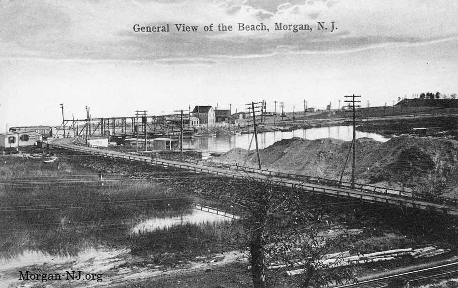
View from the Heights of Morgan toward Morgan Beach and the Keyport-South Amboy Road Bridge Over Cheesequake Creek Sometime Between 1910 and 1912.
A beyond huge THANK YOU goes to Diane Norek Harrison not only for providing me with the original version of the above picture postcard image showing what Morgan Beach/Cheesequake Creek looked like at the turn of the last century but for her always interesting articles typically about the local history of the areas around the Morgan area. Seeing this image for the first time blew my mind! Subsequent to the original posting of this image, I managed to acquire an original copy, shown above, which has much better image quality. Enjoy!
This incredible picture post card shows what the Morgan Beach area looked like just over 100 years ago. Here are my observations; please let us know your observations in the “Comments” section at the end of this posting:
- While I don’t have the exact date of this photo, we know it is sometime between when the Jersey Central Traction Co (JCT) opened trolley service on March 16, 1905 and when this swing bridge over the Cheesequake Creek was removed in 1912.
- Using some additional information provided by the late Mr. Joseph F. Eid, Jr., who was probably the foremost authority on the subject of the Jersey Central Traction Company and had authored numerous books on the subject of trolleys of New Jersey including the quintessential book “Jersey Central Traction Co., Trolley to the Bayshore”, we were able to narrow this date range down a little further. Shortly before he passed away, Mr. Eid examined this photo and zoomed in on the JCT car located just to the left of the bridge. He did this because he monitored Morgan-NJ.org but mostly because he was enormously passionate about the JCT! Based on the number of windows on the side of the car (12) and the railroad roof type, Mr. Eid concluded this was one of four cars ordered from the J. G. Brill Company of Philadelphia, PA and delivered in March 1910. So, this photo was taken some time between March 1910 and late 1912! Thank you, Mr. Eid!
- If the Jersey Central Traction Company trolley was going toward South Amboy, then it was about to start the incline on the trestle leading to the truss bridge over the New York & Long Branch railroad.
- The trolley is next to a building marked “Trolley Waiting Room”.
- The railroad tracks at the bottom right are from the New York & Long Branch Railroad. This railroad opened in 1875.
- The road in the picture post card was known as the Keyport-South Amboy Road. It was also known as the “County Road”. To the right of where it crossed the railroad tracks (out of frame) is present day Old Spye Road (see the to-be-reposted write-up).
- The dirt Keyport-South Amboy Road is on top of the 532 feet long sheet-pile revetment dam which was put in place in 1883 as part of the effort to redirect the flow of Cheesequake Creek into Raritan Bay (see the to-be-reposted write-up).
- The marsh area on the left side of the dam was the original mouth of Cheesequake Creek (see the to-be-reposted write-up).
- The bridge over Cheesequake Creek pictured was built in the late 1890’s in the closing days of horse pulled wagons, i.e., it wasn’t designed for motorized trucks or those new fangled automobiles.
- The redirected 1883 Cheesequake Creek channel to Raritan Bay is not fully visible and is located to the left of the swing bridge (see the to-be-reposted write-ups).
- The mounds of dirt on the right side of the road next to the railroad (and later land fill on the left side of the road) eventually became the site of Henry Luhrs’ boat companies Morgan Yacht Basin and Henry Luhrs Sea Skiffs (see the to-be-reposted write-up).
- Also previously located on that land fill was the Morgan Dancing Pavilion, which was also a bar and a boarding house, and William Lockwood’s Boat Rental. My mother’s two grandfathers used to sell bait to Mr. Lockwood! Ultimately Mr. Lockwood moved a little down the road and now Lockwood Boat Works is the largest marina in Morgan.
- You can’t see most of Cheesequake Creek as it runs parallel with the road and is occluded by the mounds of dirt.
- The waterway seen heading toward the top right is called Stump Creek. This portion of Stump Creek was filled in and the creek redirected when the current Morgan Bridge was built in the early 1940’s (see the to-be-reposted write-up).
- Morgan Beach was (and still is) located on the right side of the bridge.
- By 1919, a colony of bungalows had sprung up on Morgan Beach (see the to-be-reposted 1919 & 1930 maps write-up).
- The original Morgan [train] Station was located at the intersection of the Keyport-South Amboy Road and the railroad tracks. People used to take the train from the northern New Jersey cities, stop at Morgan Station, then walk over to Morgan Beach (“The Jersey Shore”). My mother, her parents, brother, aunts, uncles and cousins used to come from Jersey City to their bungalow on Morgan Beach.
- I don’t know what the buildings on Morgan Beach in the photo were but would like to! If you know, please let us know in the “Comments” section at the end of this posting.
- By World War II, the first building next to the bridge was Kaisers Pavilion. This was where my parents met during the war. If they had not met there at that time, you would be reading some other web site right now!
I first encountered Diane Norek Harrison’s work in the summer of 2009 when I was doing preparation work for this Morgan-NJ.org web site. The subjects Diane wrote about were in the same flavor as what I had in mind for the web site. In fact, one of the greatest things about her articles was that it led to me to someone in Morgan who had taken a New Jersey history class at RutgersUniversity and who wrote a paper on the history of Morgan! Awesome! Even more incredible for me was that she ended up living only a few houses away from the house I grew up in! Because of Diane’s writing, I got to meet my separated-by-time neighbor and I look forward to seeing her and her husband again – and hopefully meeting Diane – one of these next times that I’m in Morgan.
Diane’s columns can be seen on the Atom Tabloid & Citizen-Gazette website. In the SEARCH section which it says “Search & Hit Enter”, type “Remembering the Past” then press the Enter key. You will see a treasure trove of local history.
Originally posted on November 7, 2010.