The New Jersey Ship Canal – It Never Happened
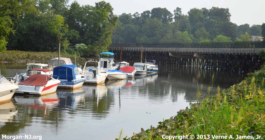
Present Day Location of What Would Have Been the Bordentown Terminus of the NJ Ship Canal.
In the early part of the Twentieth Century, starting during the time period when the United States was building the Panama Canal, a plan to build a third trans-New Jersey canal, named the New Jersey Ship Canal, was in the works. Unlike the existing Morris Canal or Delaware & Raritan Canal, which were constructed in the early 1800’s, had locks to accommodate the geography, and were nearing the end of their usage; this canal was ultimately intended to be a sea level canal where the lone lock was to be for the purpose of protection from “Spring freshets”. This canal, if it had been built, would have very much altered how Morgan would later develop as this canal was planned run between Morgan and Bordentown. Today’s Morgan would be a very different place.
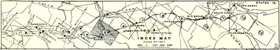
Proposed Route of the New Jersey Ship Canal, 1911. Morgan Would be in Map #11. Image Courtesy of the New Jersey Environmental Digital Library.
http://hdl.rutgers.edu/1782.1/rucore00000002110.Map.000060918
The New Jersey Ship Canal was envisioned as another link in an already existing extensive network of primarily inland waterways connecting the industrial northeast between Norfolk, Virginia to Boston, Massachusetts. As had what always seemed to be the tradition of the state of New Jersey, this canal would link what was then the largest ship building center in the world (Philadelphia, PA) with the then largest city in the world (New York, NY).
It was envisioned that this canal would allow for freight costs to go down, especially for coal which was the primary source of energy in homes and factories at the time, by:
- Shortening the distance of the route by eliminating the need to go around Cape May and along the east coast of NJ. This would shorten the trip between Philadelphia and New York from 274 miles to 87 miles resulting in lower fuel and crew costs.
- Lowering or eliminating the need to transfer cargo between land (i.e., rail) and water modes of transportation.
- Permitting the use of box barges which cost less than half as much per carrying ton as ocean-going barges and allowed for smaller crews.
- Providing a route with no extreme turns which would cause great difficulties for barge traffic.
An additional benefit was making the journey more schedulable by eliminating the problems caused by going into the open ocean, e.g., storms, or not having to go further north on the Delaware River which would get blocked by ice during the winter north of Bordentown. If the canal had been in place prior to World War I, the menace of German submarines off the coast of New Jersey to shipping during both World Wars would have been eliminated. Transit time through the 33.7 mile long canal was estimated to be about 8 1/2 hours versus the minimum 21 hours to go around Cape May.
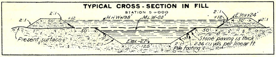
Cross-Section Example of the Proposed New Jersey Ship Canal, 1911. Image Courtesy of the New Jersey Environmental Digital Library.
http://hdl.rutgers.edu/1782.1/rucore00000002110.Map.000060918
The western terminus of the canal would have been located in Bordentown where Crosswicks Creek meets the Delaware River right where present day Interstate 295 crosses Crosswicks Creek. The canal would have then proceeded northeasterly up Crosswicks Creek Valley through the highlands heading just east of Edinburgh, midway between Princeton Junction and Hightstown, and two miles west of Cranbury, to a point three miles west of Jamesburg. It would have then traversed toward and crossed the Camden & Amboy Railroad just north of present day Helmetta. At this point it would turn slightly more northward and run roughly parallel with the railroad and Bordentown Avenue past Spotswood and Old Bridge. Just east of where Bordentown Avenue makes the S-turn under the Camden and Amboy Railroad right of way, it would have turned slightly east to pass through where present day Routes 9 & 34 intersect to enter the Cheesequake Creek basin. It would then have consumed Cheesequake Creek then entered Raritan Bay at Morgan Beach. Interestingly enough, the present day channel at Morgan was set to 200’ wide when it was constructed in 1883 which is the same width the entire canal was ultimately supposed to be. Guess this width was not randomly selected when it was called out for in the 1879 US Army Corps of Engineers survey maps.
I haven’t yet found what kicked off the effort to build the canal. Perhaps President Theodore Roosevelt’s creation of the Inland Waterways Commission in March 1907, whose charter was to prepare and report “a comprehensive plan for the improvement and control of the river systems of the United States,” sparked it. The thirteen charts published in 1911 by the US Army Corps of Engineers and signed by Colonel William M. Black regarding the “Sea Level Project Between Bordentown and Cheesequake Creek,” would have taken a number of years to create and indicate they are based on surveys from 1909, 1910 & 1911.
Here are excerpts from some on-line reference sources which have further information regarding the New Jersey Ship Canal:
August 5, 1894, New York Times
January 11, 1913 South Amboy Citizen; Page 1, Column 3
The State Commission, in conjunction with the federal authorities, has under consideration alternative plans for a twenty-five-foot sea level canal, an eighteen-foot sea level canal, a twelve-foot sea level canal, or a twelve-foot lock canal.
Whatever the decision, it is the intention to so construct the waterway as to allow of an ultimate depth of twenty-five feet. As to width, the present plan is to have the waterway 200 feet across at the top and 125 feet at the bottom. Agents of the commission have been obtaining options on a 1,000-foot right of way. The land that is in excess of the 200 feet that is to be used for the canal proper is intended for industrial sites…
It was also the idea of the commission to construct terminals and warehouses at each end of the canal for the use of boat owners, railroads and industrial concerns which will use the canal for freight purposes…
August 14, 1913, New York Times
December 6, 1913, South Amboy Citizen; Page 1, Column 1
House Resolution 9688. … in accordance with the report submitted in House documents 196, Sixty-third Congress, first session… Bill submitted by House of Representatives Representative Thomas J. Scully [of South Amboy] of the House Rivers and Harbors Committee. Canal to be a twelve-foot lock waterway, ninety feet across, capable of development into a twenty-five-foot sea-level canal… Canal to be completed within eight years.
November 30, 1919, New York Times
This is the best article about the canal that I can point you to and includes a nice drawing of the “Route of Atlantic Coast Inland Waterway from Norfolk, Va., to Boston, Mass.” Thanks to Tom Reynolds for pointing it out to me.
November 7, 1919, New York Times
November 30, 1919, New York Times
From 1921 New York Legislative Documents
Construction with a 25-ft. depth and 125-ft. bottom width was approved in 1912 by a special board of engineers of the War Department. In 1913 the chief of engineers reported in favor of a lock canal of 12-ft. depth and 90-ft. bottom width, susceptible to later elimination of locks and enlargement to the larger dimensions. The New Jersey Board of Commerce and Navigation in 1916 advocated the larger sea-level canal, and the New Jersey Legislature in 1917 passed an act authorizing the Board to acquire the right-of-way for such a canal and cede it to the Federal Government, conditional on a Federal appropriation for construction. The chief of engineers, in a report made August 9, 1918, while recommending early construction, held to the smaller lock canal, the cost of which was estimated at $20,000,000 as compared with a figure of $45,000,000 for the 25-ft. sea-level channel.
September 7, 1928, South Amboy Citizen; Page 1, Column 1
The discussion continued through to 1928 where Congressman Harold G. Hoffman (of South Amboy) “made a vigorous plea for the New Jersey Ship Canal project.” By that time the inland waterways extended from Florida to Boston.

Proposed New Jersey Ship Canal in the Crosswicks Creek Area Near Bordentown, New Jersey, 1911. Image Courtesy of the New Jersey Environmental Digital Library.
http://hdl.rutgers.edu/1782.1/rucore00000002110.Map.000060918
If the New Jersey Ship Canal had been built, can you imagine how different things would be in central New Jersey now – not just in Morgan? The Turnpike and the Parkway would have still happened but would have had to cross on high bridges over the canal so as to not impact shipping traffic; same for any other road bridges. Both Raritan Bay and the Delaware River would have had to have been dredged. Perhaps the landfill making up the eastern portion of Morgan and South Amboy would have been filled in earlier than in the 1950s and might actually have had to have been bigger to accommodate the dredging of both the Raritan bay channels (e.g., “Red Bank Reach”, “Ward Point Bend”, etc.) and the New Jersey Ship Channel. Any railroad which crossed the canal would have had to have some type of 200’ wide and somewhat high bridge including the present day NJ Transit railroad bridge over Cheesequake Creek. Morgan’s present day Route 35 bridge would also have had to have been wider and probably taller.
According to a US Army Corps of Engineers map entitled “Intracoastal Canal, New York Bay-Delaware River Section”, dated June 30, 1933 (also provided by Tom Reynolds – thanks again, Tom!), there were plans for a canal which bypassed Morgan and instead went around Sayreville. On this map, the route of the canal transitions from the Raritan River, across Crab Island, and heads south along the route of the South River between the Boroughs of Sayreville and South River. I don’t know whether it ultimately then connected to the same route or a different route to Bordentown.
It isn’t clear when the idea of the New Jersey Ship Canal ultimately died. According to a search on the NY Times’ web site, the New Jersey Ship Canal was still being pushed for as late as 1949! I haven’t found anything yet indicating when it stopped being a viable idea. By the time of the discussions regarding the New Jersey Ship Canal, the notion of building and using canals was pretty near the end – excluding the Panama Canal which was a huge deal. At this time I suspect the advent of the Great Depression, which started in October 1929, sealed its fate.
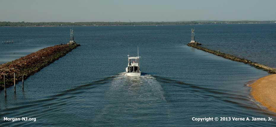
Present Day Location of What Would Have Been the Morgan Terminus of the NJ Ship Canal.
In a way, this canal was a “Back to the Future” event personally for me in that if it had been built, the bungalow colony on Morgan Beach would likely have been removed decades earlier and Henry Luhrs likely would never have built his boat factory between the railroad and road bridges on Cheesequake Creek, which means that my parents would have never met at Kaiser’s Pavilion on Morgan Beach. In other words, you would be reading something else right now.
Originally posted on June 5, 2011.
Recently came across a bronze (?) platte of NJ complete with countours valley ridges with canal shown includes commissioners names and cities. What would it be worth, has no date made in Newark, NJ by the ART METAL WORKS imprinted on shield (no date) with 5-five commissioners names from Trenton, Rutherford, New Brunswick, Tenafly, Newark..
Sorry, I have no idea.