Morgan Memories – 1928 Photo of the Route 35 Bridge over the Railroad
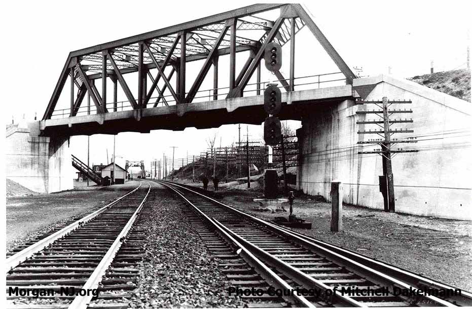
Pratt Truss Bridge Currently Utilized for the North Bound Lanes of Route 35 as Seen in 1928.
An enormous THANK YOU to Mitchell Dakelmann for providing the above amazing 1928 photo of the Route 35 bridge crossing over the New York & Long Branch (NY&LB) Railroad in Morgan. Mitchell is a member of the 75-year young North Jersey Chapter of the National Railway Historical Society.
For those of us who grew up right near this location, there are a million things of interest in this photo. They say a photo is worth a thousand words, well, let’s give it a try:
- This photo was taken on February 3, 1928, during the “Roaring 20’s”, before the economic disaster known as the Great Depression started as the result of the October 29, 1929 stock market crash the following year.
- This photo is looking south toward LaurenceHarbor.
- According to the NJ DOT web site, this bridge was built in 1924.
- The photo is believed to have been taken by Union Switch and Signal, Inc. (US&S) of Swissvale, Pennsylvania and was probably showcasing their multi-light signal assembly and the railroad switch all in one photo. Incidentally, US&S was founded by George Westinghouse in 1881.
- Union Switch and Signal later received a contract from the US Government during the early stages of World War II to manufacture 200,000 pistols.
- This photo was taken 9 ½ years after the T. A. Gillespie Shell Loading Plant explosions occurred a mile and a half to the west.
- The bridge design type is known as a Pratt Truss.
- Prior to 1927, this road was designated as Route 4. In 1927, it was renumbered to New Jersey State Route 35.
- This bridge is still in place and is currently for the two northbound lanes of Route 35. At the time of this photo, it was both the northbound and southbound lanes of Route 35.
- Note that the railroad tracks bear left toward the 1912 bascule bridge which replaced the 1870’s swing bridge (see the page about the Bridges of Cheesequake Creek) over Cheesequake Creek.
- Notice the glass insulators on the pole on the right (west) side of the photograph. These glass insulators were a light green color and are now Collectors items. The poles have long since been removed. I don’t know whether the wires on the poles are telephone, telegraph or electrical.
- Notice the staircase coming down from the southbound land of Route 35 to the Morgan Station shelter. Neither the staircase nor the shelter is still there. This staircase would have been torn down and land fill put in its place when Route 35 was widened in the early 1940’s.
- In 1945, a parallel bridge (New Jersey Bridge # / NJDOT Structure #: 1222152) was built to accommodate the south bound lanes of Route 35 thus making this bridge northbound only. The Morgan Station shelter was removed when the southbound bridge was built.
- On or near this site, this bridge replaced a trestle and bridge of the Jersey Central Traction Company trolley line which ran through Morgan from 1905 to 1923.
- Notice the accumulation of four years of steam locomotive soot in the middle of the bridge.
- This bridge would have connected, via an inclined road, to an earlier bridge over Cheesequake Creek (i.e., to the left of this photo going east toward LaurenceHarbor). This earlier Cheesequake Creek bridge was torn down after the current Route 35 draw bridge was finished in 1942 (see earlier posts on this topic).
- The track in the foreground on the right (southbound track) has a switch which is no longer there. In fact, the entire third set of tracks are no longer there. It is believed by my good friend Ken that this set of tracks was the interchange siding from the long defunct Raritan River Rail Road (RRRR). This siding was where the RRRR would park train cars to be transferred to the NY&LB RR. The RRRR was one of three railroads which ran through Sayreville & South Amboy (Camden&Amboy, New York & Long Branch and Raritan River Rail Road).
- You can still see remains of the RRRR tracks further north, just north of the end of paved portion of Cliff Avenue, where the southbound track switches off to a side railing. The remains are near this switch.
- Cady’s, a seafood restaurant, was located just to the left of this bridge, next to the Cheesequake Creek jetty. Cady’s would later be renamed the Robert E Lee Inn.
- Notice the tracks are composed of rail segments bolted together vs. the continuously welded rails installed in the early 1980s.
- Just to the left of the bascule railroad drawbridge is the future site of Henry Luhrs Sea Skiff Company and later Zuback’s Heavy Metal Marine, Inc.
- Prior to the opening of this bridge, Old Spye Road was the main road for city slickers heading to the Jersey Shore. Old Spye Road used to cross these railroad tracks between the Cheesequake Creek railroad bridge and the Morgan Station shelter. This railroad crossing was a legendary site for summer traffic jams.
- The NJ DOT web site indicates the following about this bridge:
The skewed Pratt thru-truss bridge on concrete abutments has bolted repairs at several verticals near the bottom gusset plates. The vertical and diagonal members are riveted built-up H-sections, while the chords re box sections. The struts at the top chord are latticed between angle sections. The new deck has aluminum Jersey-type barriers at both curb lines. The span is a technologically undistinguished example of what by 1924 was a common type used by the CNJ [Central New Jersey Railroad]. - A good number of photographers have taken photos of trains looking north (toward South Amboy) from the vantage point of this bridge. The fantastic book “The Unique New York & Long Branch” has a few very nice photos from this vantage point. Too bad I never thought to do that! Maybe the next time I’m out that way. In the mean time, if you have a good photo from this bridge, please send it my way.
- Today this bridge contains a tall wall on the pedestrian walkway on the track side which makes it nearly impossible to take train photos. I don’t specifically know why the wall was put there. Perhaps to stop people from jumping off or throwing things. Perhaps it, and the continuous guardrail, was erected in response to a pretty horrible and probably fatal auto accident which occurred some time in the middle of the night in the 1970s which woke up the neighborhood. A northbound car didn’t make the slight left curve and ran into the north side diagonal truss.
This photo made me realize how a photo which is may be mildly interesting to one person can be of overwhelming significance and interest to someone else. I am so appreciative of Mitchell Dakelmann for this gift and welcome similar types of content contributions from other Morgan-NJ.org viewers.
Did I hit a thousand words?
- Bridge Type: Pratt Thru-Truss
- Number of Lanes: Two northbound
- Leaf Contains: Two lanes of traffic and one sidewalk.
- Total Length: 155 feet
- Deck Width: 30 feet
- Number of Spans: 1
- Length of Longest Span: 155 feet
- New Jersey Bridge # / NJDOT Structure #: 1222151
- Construction Completed: 1924
- Designer/Patent: CNJ RR Office of Engineering
- Sponsor/Owner: New Jersey Department of Transportation (NJDOT)
- Milepost: 47.52
- Material: Steel and concrete
Originally posted on October 9, 2009.
Another great article! Thanks!
If I am not mistaken, the higher walls on the bridge coincided with the installation of the catenary wires on the NJ Transit tracks below when electric service was extended to Matawan.
very interesting love knowing the history of the area