Morgan Memories – The Other Trolley Line in North Morgan
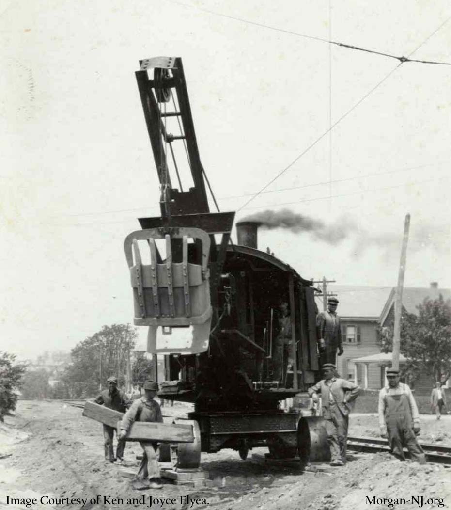
Road Construction on South Pine Avenue, Circa 1916. Image Courtesy of Ken and Joyce Elyea.
This topic evolved out of the one about the Jersey Central Traction (JCT) Company’s Tracks Thru Morgan page combined with a number of images provided to me by the indefatigable Joyce Elyea that her husband Ken had purchased some time ago. After getting over not knowing that there had once been a trolley line which went through Morgan, it was even more interesting to find out that technically there were at one time two trolley lines in Morgan though the second and bigger one, ultimately named the Public Service Railway (PSRy), was in Morgan for a shorter time and distance.
According to the authoritative book on the subject, “The Public Service Trolley Lines in New Jersey” by Edward Hamm, Jr., this second trolley line, initially the Middlesex & Somerset Traction Company, was a little over 16 miles long and connected South Amboy and New Brunswick. It opened for regular passenger service on Saturday, August 11, 1900. The tracks extended into Morgan for the relatively short distance of about a quarter of a mile on present day South Pine Avenue. The track was on the west side of South Pine and went to a point somewhere just south of Christ Church Cemetery. This was the end of the line and the trolley tracks formed what is called a wye. This configuration was needed in order for the trolley cars to be able to turn around. Trolley cars would go south on South Pine Avenue, curve east across South Pine Avenue at the wye then backup onto the other section of the wye which curved back southward on South Pine Avenue. At this point the trolley would now be facing north in order to go back through South Amboy to New Brunswick.
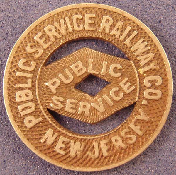
Token from New Jersey Public Service Railway – About the Size of a Dime.
A few years later, the Jersey Central Traction Company (JCT) would come through Morgan and meet up with this line which by that time had been acquired by the Public Service Corporation of New Jersey and likely would have then been named the United Street Railway Company of Central New Jersey. Note that this line would later be merged into the Public Service Railway Company on August 20, 1907.
According to Mr. Joseph Eid’s book “Jersey Central Traction Co. Trolley to the Bayshore,” the JCT appears to have had a junction with this trolley line on South Pine Avenue and shared the track between there and the South Amboy railroad station on Broadway and John Street.
The track configuration would have been like this for the five years between March 16, 1905 – when the JCT opened – and March 13, 1910 – when the JCT opened up the westward turn off toward Portia Street. This junction between the PSRy and the JCT must have, if it actually had existed, been located somewhere just north of present day South Pine Avenue at Wessco Street. This route would have extended north past present day Christ Church Cemetery (then known as Doane Memorial Cemetery), right onto Bordentown Avenue and left onto Broadway ending at the train station which at that time was situated on the west side of the railroad tracks between John Street and Henry Street.
The Public Service Railway was Huge!
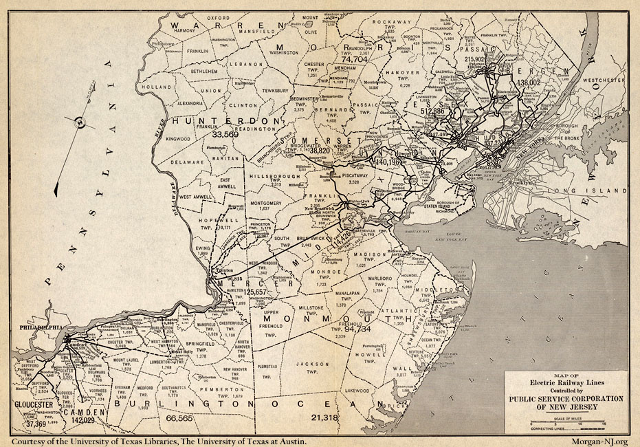
1913 Map of the New Jersey Public Service Railway. Image Courtesy of the University of Texas Libraries, The University of Texas at Austin.
According to this 1913 map, the PSRy was huge! It extended from the Camden area, through Burlington and Trenton, across central New Jersey connecting to the New Brunswick/South Amboy line at Milltown. Our our branch went through South River, Sayreville, South Amboy and, by 1913, into Perth Amboy. The other branch from Milltown lead to New Brunswick, Metuchen, Woodbridge, Elizabeth, Newark, all the way to Paterson/Hackensack, and Englewood. Additionally, there were extensive lines in the Bayonne, Jersey City and Hoboken areas. Huge!
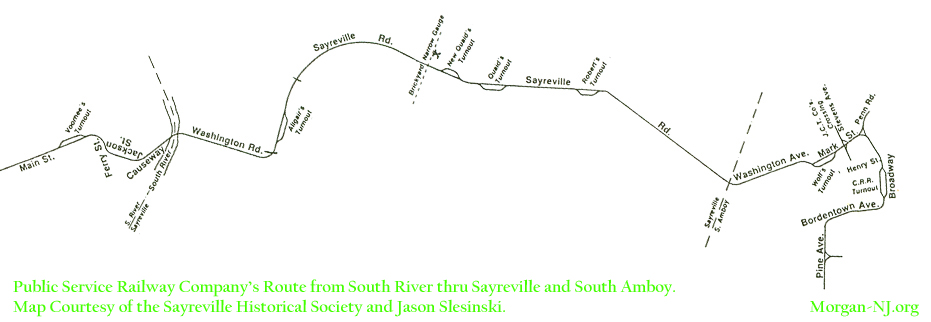
Map of the Public Service Railway in Sayreville, South Amboy & Morgan. Image Courtesy of the Sayreville Historical Society and Jason Slesinski.
According to the above map, also contained in Jason Slesinski’s excellent book “A Cultural History of Sayreville,” from South River the route entered Sayreville across the long gone South River Causeway Bridge and headed east on Washington Road. It turned left onto Sayreville Road, which apparently was renamed some time later to Main Street, then proceeded to wind its way through Lower Sayreville. Near the current location of the Sayreville Police Department, the trolley had a grade level crossing with the Raritan River Railroad. There is a great photo of a trolley coming to this crossing in Jason’s book. The trolley line route then must have continued on the bridge across the Camden & Amboy Railroad tracks then crossed the Raritan River Railroad interchange yard tracks while making the left onto Washington Avenue to enter into South Amboy. Once in South Amboy, the trolley line again passed over the Raritan River Railroad for the third of four times near the site of long gone Bergan Station, located off of Elm & Center Streets, then past Sacred Heart Church onto Main Street. On South Amboy’s Main Street, between Stevens Avenue and Broadway, starting in 1910, the PSRy shared about 1000’ of track with the JCT before turning south on Broadway. From Broadway, the trolley line took a right onto Bordentown Avenue heading west to where it would again meet up with the JCT at Stevens Avenue and run parallel until Pine Avenue after having crossed over the Raritan River Railroad for the fourth time! At Pine, it would make a left and head to the end of the long line in Morgan. At least they were in Morgan until, I believe, sometime around 1916, which brings us to our next section!
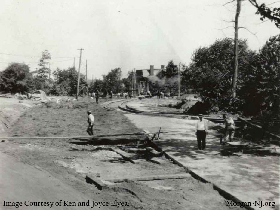
Sometime between September 1915 and May 1917 South Pine Avenue, indeed the whole road between South Amboy and the railroad tracks near Morgan Station, had a major overhaul. The road was redone with the famous paving stones still found to this day on Old Spye Road (and hopefully for a good long time to come). The three black and white construction photos on this page, labeled “Pine Avenue” came from Ken & Joyce Elyea, of course, two of this web site’s greatest supporters. After some analysis on all our parts we now believe we can identify exactly were all three of these photos were taken! As indicated above, it is believed they were most likely taken in 1916 when South Pine Avenue was being redone. Two of them, I believe, tell a particularly interesting and unexpected story which explains something if you look at it as being the end of the line.
Steam Shovel Road Construction on South Pine Avenue, Circa 1916. Image Courtesy of Ken and Joyce Elyea.
This photo shows five road workers, a pedestrian and a steam shovel operator working on what is present day South Pine Avenue. To the right of the photo and in back of them are the PSRy tracks leading from present day Christ Church Cemetery area toward Bordentown Avenue seen here on the left part of the photo. Above them are the overhead power wire and its support cables. You can see the Jersey Central Traction Company’s trolley tracks on Bordentown Avenue going from left to right. Within this section of Pine Avenue, tracks going in that direction could only be the tracks on Bordentown Avenue. You’ll note that the steam shovel looks very much like the coal powered steam shovels used to build the Panama Canal between 1904 and 1914, just two years earlier. This info helps support the believed time frame of the photographs.
The two houses in back of the steam shovel appear to match two of the present day houses located on the east side of South Pine Avenue between Ferris Street and Gordon Street. It was these houses and the track on Bordentown Avenue which caused us to conclude where this photo was taken, i.e., looking north on present day South Pine Avenue between Gordon Street and Ferris Street!
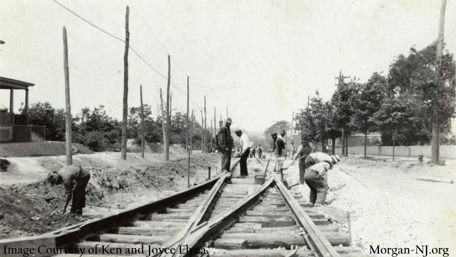
If you look at the image at the very top of this page, aside from the dozen or so road construction workers shown, the image is very interesting in that it has a trolley track switch in it. I have to say this image left me stumped for quite a while. At that time, I knew very little about this trolley line, not even its name. The only place I knew of where there would have been a switch on South Pine Avenue would have been the wye mentioned previously.
The problem with that theory was that the elevation of the street and the terrain on the sides of the street didn’t support it. This photo appears to show that the road had a downward slope. The area of South Pine Avenue around present day Wessco Street is flat and the terrain on either side of the road is on the same level as the road. The section of South Pine Avenue just south of the entrance to present day Christ Church Cemetery has a downward slope and elevated terrain to the left but on the left side of this photo there are portions of a house. Being it is a cemetery, there would not have been a house there so this couldn’t have been the spot.
Joyce came up with the key clue when she indicated this was likely present day South Pine Avenue looking north toward the City of South Amboy as well as looking toward the area where the steam shovel had been in the previous photo, hence the below picture post card image (also supplied by Joyce).
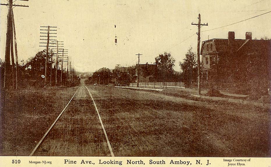
Looking North on South Pine Avenue, Circa 1900-1915. Image Courtesy of Ken and Joyce Elyea.
This image shows the area of present day South Pine Avenue looking north when the street appears to have been dirt, i.e., before the road construction of 1915-1917. There are a number of reference points in this image, to use in comparison with the other images on this page, to make note of. Compare many of the below items between the photo with the trolley track switch and the one just above showing “Pine Avenue Looking North”:
- The direction, as per the title of the picture post card, is looking north.
- The road is dirt which means it is older than the other three black & white photos on this page.
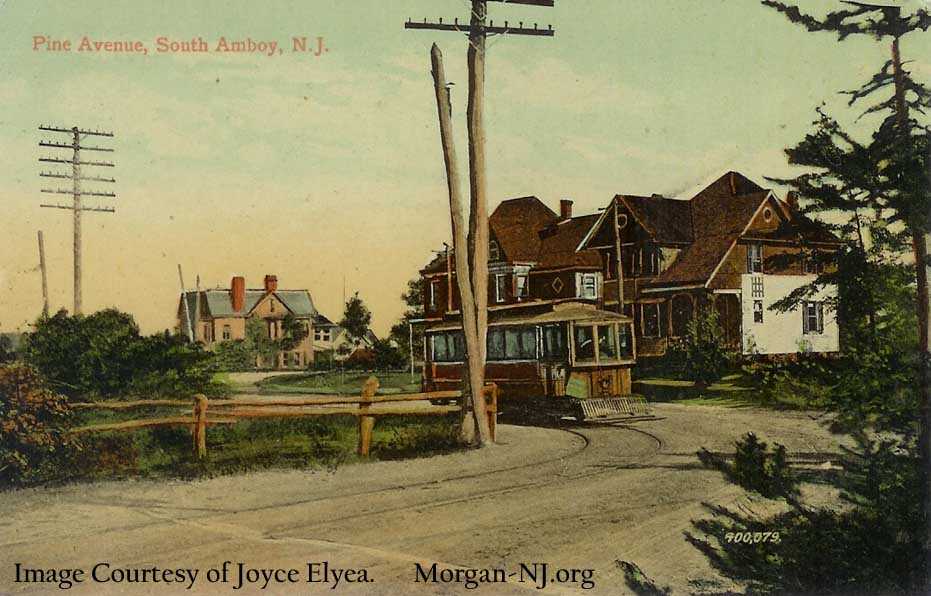
Trolley Heading South on South Pine Avenue, Circa 1900-1915. Image Courtesy of Joyce Elyea.
- The house on the right side with the flat roof matches the far left house in the above image and is located (still!) at the northeast corner of South Pine Avenue and Louisa Street.
- The fire hydrant seemingly located in front of this house but is actually located at the corner of South Pine Avenue and Louisa Street.
- The picket type of fence in back of this fire hydrant.
- Next to this fire hydrant is a young tree.
- Between this fire hydrant and the pole further up the street, there are two similarly aged young trees.
- Next to the pole further up the street is a similarly aged young tree.
- The road appears to gently slope down as it heads north.
While they are not really reference points, it is interesting to note that the poles on the left side of the street contain many insulators meaning that there are many wires supported. Telephone wires? Power wires? Telegraph wires?
Now go back and examine the above photo which has the switch in it.
- The trees on the right side of the street are more mature than in the previous photo.
- The white picket fence is still there.
- The house with the flat roof at the corner of South Pine Avenue and Louisa Street is blocked by trees in this photo.
- The fire hydrant at the corner of South Pine Avenue and Louisa Street still appears on the right side of the photo. Note that there is still a fire hydrant at this location today.
- While there is a new pole next to the fire hydrant, there is still a tree near it
The top of the house barely discernible in the distance on the left above the trees appears to match the house which is still located on the southwest corner of present day South Pine Avenue and Bordentown Avenue. It has a very steep roof, two windows and some type of lattice work at the apex of the roof.
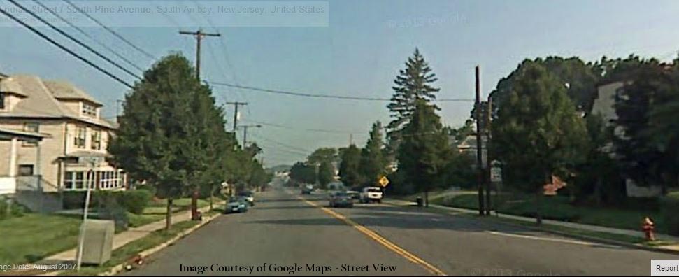
Looking North on South Pine Avenue, South Amboy – Present Day. Image Courtesy of Google Maps Street View.
The above photo is from Google Street View and is apparently from 2007. The clincher for me was on the far left side of the photo. Here is the porch, stairs and first floor roof of a building with its foundation two to four feet above sidewalk level (if they had sidewalks in 1916). Still here nearly 100 years later! On the right side of the street, you can still see the house with the flat roof and the fire hydrant. It is interesting to note that the property of the houses north of the house with the porch and stairs are a little lower, i.e., at street level.
Conclusion: The switch used to be located on South Pine Avenue between Louisa Street and Portia Street!
But why was it there?
Road Construction on South Pine Avenue, Circa 1916. Image Courtesy of Ken and Joyce Elyea.
This third black and white photo from Joyce and Ken also had me perplexed for a while in that the trolley tracks were no longer going south on South Pine Avenue but were appearing to be going toward the northwest corner of Christ Church Cemetery.
At some point a number of leads and assumptions lead me to conclude something about these tracks.
- The switch in the previous photo must have been part of the above curved route.
- The curve probably kept curving and eventually connected to the other portion of the switch thus creating a loop which would have allowed for the trolleys to turn around in a better fashion than using a wye.
- This loop configuration would also have been preferable to the wye configuration since the number of automobiles on the roads was increasing at a high rate yearly (there were 1,525,578 cars produced in 1916 with Ford alone making nearly half of them 734,811). While perhaps no big deal for horse and buggies, stopping automobile traffic on both directions on South Pine Avenue to allow a trolley car to cross over South Pine Avenue twice in order to turn around would no longer be feasible or desirable.
- After the reconfiguration of the JCT in 1910, there was no need to continue the PSRy connection to the JCT near present day Wessco Street since there were are two other places, i.e., Bordentown Avenue and Main Street in South Amboy, where the two lines either ran parallel to each other or shared the same track. In other words, transferring between the two trolley companies could have been able to have been done some place other than near present day Wessco Avenue.
- Some Facebook chatter on the “You Know You’re from Sayreville N. J.” suggested that there were still tracks in the area north of Christ Church Cemetery as of the 1950s (which means that HistoricAerials.com might show something). Another person suggested that at one time “between Monahan House and the gas station there was a trolley turntable that literally turned the trolleys around”.
- The below image is from HistoricAerials.com and clearly shows a loop like structure in the exact location described above:
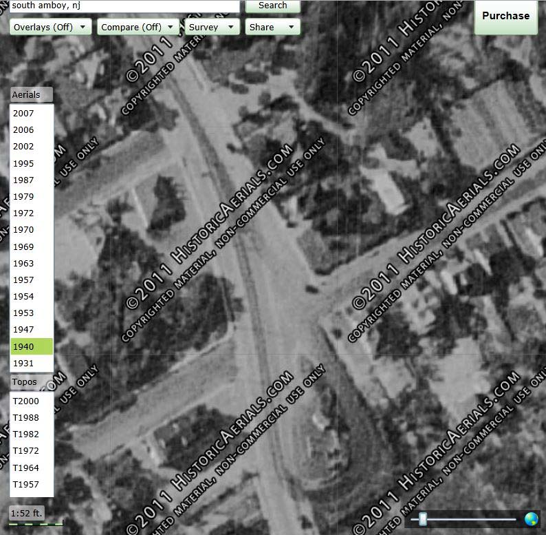
Aerial View of Public Service Railway Loop Right of Way in Morgan, NJ, 1940. Image Courtesy of HistoricAerials.com.
A few weeks after I made the conclusion that there was a loop at this location just northwest of Christ Church Cemetery, I received Mr. Edward Hamm, Jr.’s book “The Public Service Trolley Lines in New Jersey.” In it, Mr. Hamm confirmed my theory:
“Sometime after the 1911 map supplied to this writer, a trolley loop was installed on Pine Avenue displacing the previous wye operation.”
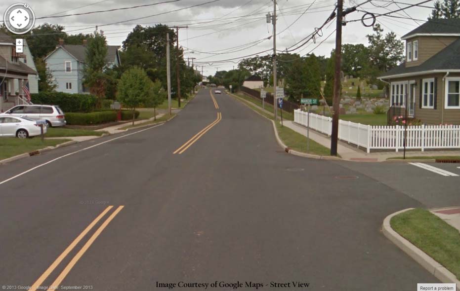
Looking North on South Pine Avenue from Manor Street, Morgan, NJ – Present Day. Image Courtesy of Google Maps Street View.
One last thought; a very nice lady who used to work in the Tax Assessor’s office in Sayreville’s Borough Hall told me that the properties on South Pine Avenue opposite of Christ Church Cemetery (technically in South Amboy) were extended because of the trolley. This was a number of years ago and I didn’t really fully comprehend what she meant at that time. I know that even as a kid I always thought the road configuration of South Pine Avenue starting at the south west corner of Christ Church Cemetery was kind of odd since it didn’t align with the other portion of South Pine Avenue south of that point. Now I know exactly why the road has the strange constriction and what the lady from the Sayreville Tax Assessor’s office meant. The trolley tracks used to run on the west side of South Pine Avenue. When the wye was removed from south of Christ Church Cemetery and the trolley loop was installed north of Christ Church Cemetery, the trolley right-of-way was no longer needed so the property was included in the parcels of land on the west side of the road. I hadn’t expected to have figured that out here!
I enjoyed the forensic research using pictures, maps, anecdotes and good ol common sense. I am a member of the Garwood Historical Committee up in union county. We had a trolley run through our town also, and i was also planning to do a study on ours. Its shown on sanborn maps, and postcards of the area. YOur 1913 map you have above shows trolley lines in union county but doesnt show them going thru Garwood but just to the left of Garwood (which is Westfield.). It appears after 1913 the trolley trax may have been extended thru Garwood towards Elizabeth. Thanks for the map. A lady who we interviewed who lived to be 103, and who passed away 2 years ago, remembers riding the Trolley into elizabeth in the 30’s. I asked her if she remembers the trolley fare and without hsitation she said 7 cents. Memory! I also haave done a couple of other research studies to prove some pictures in Garwood, much like you have done here. I thoroughly enjoyed your write up. Thank you.