This article had been wiped out about a decade ago when this website got hacked and has yet to be reposted – until now. In the intervening years, much of the then-unknown information has been discovered and has been incorporated in this update.
Much of what makes Morgan unique and historic are the few remnants remaining of its long 300+ year history. One of the coolest of the few things still present from old Morgan is Old Spye Road.
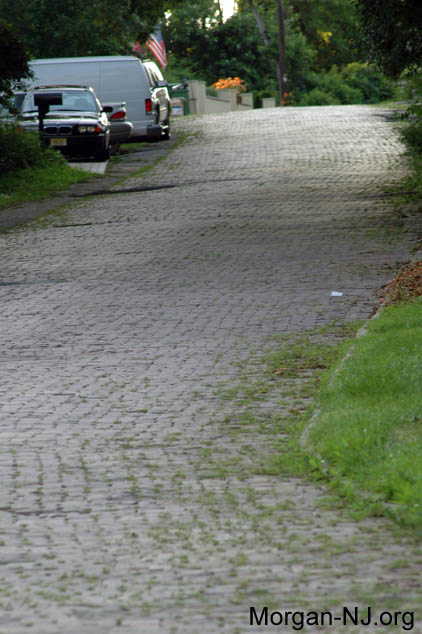
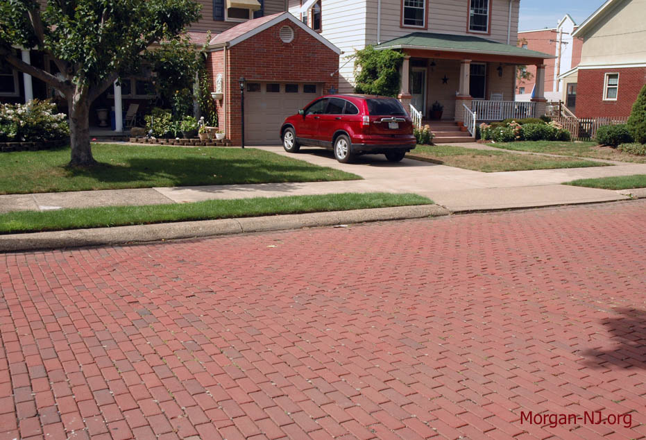
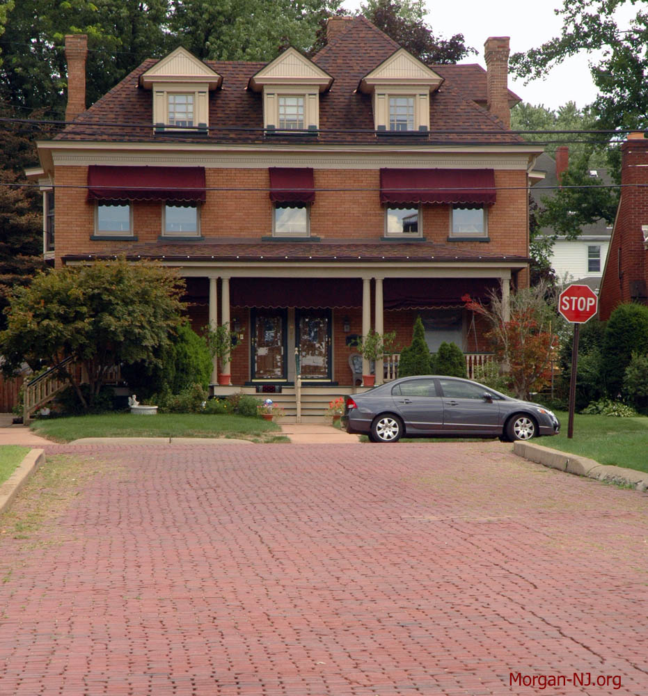
The path of Old Spye Road is unique not only for its probable near – if not over – 300+ year-long history, but also because the majority of its length is still composed of brick. While it is now “off the beaten path” and only about one-third of a mile in length, up until the opening of what is now State Highway Route 35 in the 1920s, Old Spye Road was the beaten path.
Following what most likely was originally a natural incline leading from the top of the bluff down to Cheesequake Creek, I’m guessing the road started out as a trail during the pre-European Lenni Lenape days to go from the creek to the top of the bluff. When the early European settlers came to the area in the early 1700s and they or their descendants ultimately needed to decide where to put a permanent building (later to become known as “The Old Spye Inn”) the logical place to situate it was at the bottom of the hill, opposite of the bayside of the bluff and at the intersection of Cheesequake Creek and a smaller creek. BTW, it still isn’t clear to me yet if the original builders of the Old Spye Inn were the Applegate family, the Morgan family, or someone else (I’m still leaning toward the Applegate family). Whoever it was, this location gave them sheltered access to the bay, immediate access to the creek which at the time was possibly easily crossable at low tide, and had the easy path to climb up the thirty or so feet to the top of the bluff for hunting, trading, farming or traveling to what eventually became near-by central South Amboy.
A February 18, 1858 act of the New Jersey Legislature was approved which no doubt lead to the first road, the “County Road”, which replaced that path down the west side of the bluff in Morgan with something wider:
1. BE IT ENACTED by the Senate and General Assembly of the State of New Jersey, That James R. Morgan, Abraham Everitt, Charles Fish, William Ross, William W. Seward, Timothy Wood, and Charles S. Clark, and their associates and successors, are hereby constituted a body corporate, by the name of “The South Amboy and Cheesequake Bridge Company,” for the purpose of building a draw or swing bridge over and across Cheesequake Creek, at or near its mouth.
11. And be it enacted, That the said company may construct roads on the salt meadows on either side of said creek, from the said bridge to the upland, and put and keep the said roads in good condition and repair, in order to maintain a good and safe way for the passage of public travel.
Throughout time, that county road appears to have been known as Route 4, Main Street, Amboy to Keyport Road, or just Keyport Road before its current moniker of Old Spye Road. See this article discussing the history of the Bridges of Cheesequake Creek. Sometime after the 1930s, the road was renamed after the Old Spye Inn. Note that both the inn and the road were in turn indirectly named for the British spy who was, according to local Morgan folklore, hung at the site during the American Revolution (this is yet another hoped-for future posting).
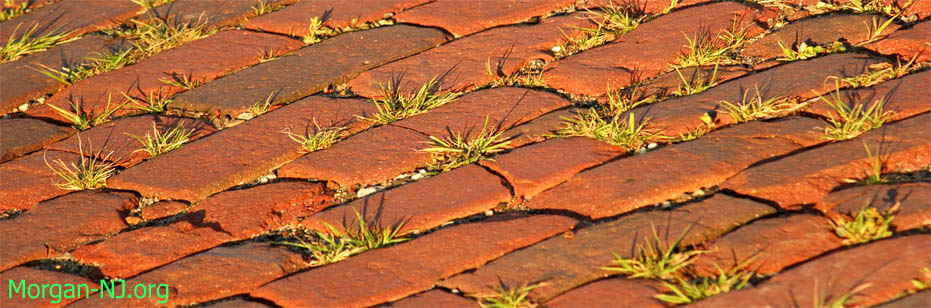
In addition to the ‘e’ at the end of “Spye”, the bricks are what make Old Spye Road so unique. The bricks making up Old Spye Road are a special type of brick known as “Paving Blocks” and have special properties when compared to “Face” bricks which are used for stairs, fireplaces, chimneys, walls, and the facades of homes. Paving blocks must be durable enough to be able to withstand rain, freeze/thaw winter weather cycles, and the frequent compression stresses imposed on them by vehicular traffic without chipping, degrading, or cracking.
I was very surprised to learn that the bricks making up Old Spye Road were not manufactured by the Sayre and Fisher Brick Company. Like Morgan itself, the Sayre and Fisher Brick Company was located in the Borough of Sayreville. In its day, it purportedly was the world’s largest producer of bricks pumping out over an astounding one million bricks per day. It appears that paving blocks were not one of the types of products Sayre & Fisher produced. In 1921, Sayre & Fisher was not listed as one of the twenty-five companies making up the Eastern Paving Brick Manufactures’ Association.
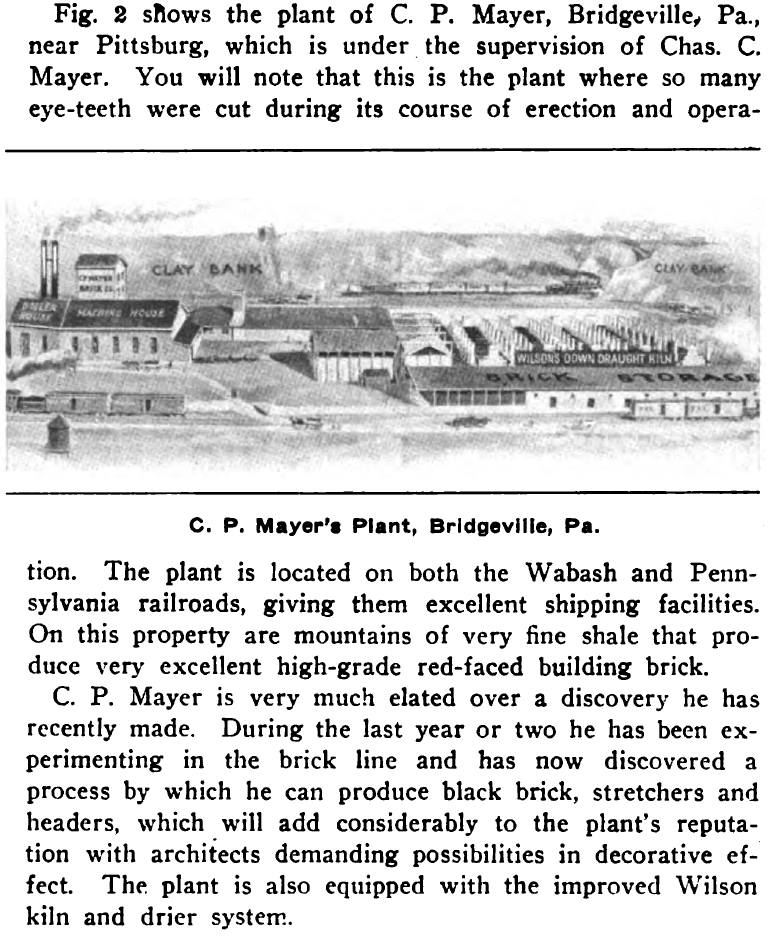
Old Spye Road bricks were actually manufactured by the C. P. Mayer Brick Company which used to be located in the town of Bridgeville in western Pennsylvania 12 miles south of Pittsburg’s Union Station. The C. P. Mayer Brick Company was founded in 1903 and used clay and shale from local hills to create each approximately 3 3/4” x 3 3/4” x 8 1/2” paving block.
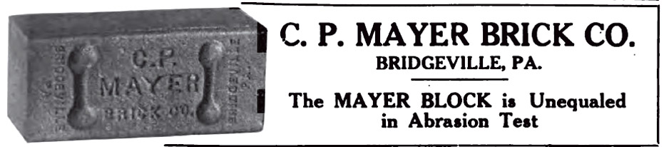
According to Mr. Casper Peter Mayer (1879-1934), Founder and President of C. P. Mayer Brick Company,
“During the year of 1905, while tied up with a contract in delivering face brick, we were compelled to close down our works or turn to make some other product than face brick, and consequently took up the manufacture of paving block. Our first attempt was a failure, but after putting in a mixing bin and making some changes in composition, we have succeeded in making paving block which now stand a test equal to any.”
As of 1910, the C. P. Mayer Brick Company was producing 20,000 paving blocks per day using a process where the blocks were burned for 14-15 days in a Wilson down-draft kiln. The area around the present-day GE Lighting Glass Plant and Hamlin’s Automotive in Bridgeville, PA on Mayer St is where the brick company was located 100 years ago.
The Morgan-NJ.org article “Morgan Monument – Paving Stone Road from South Amboy Thru Morgan” discusses when and who originally placed the paving stones on present-day Old Spye Road citing many articles from the South Amboy Citizen newspaper from the times. The “paved” road would have been vital to supporting the nearby T. A. Gillespie Shell Loading Company, which was built in and blew up in 1918.
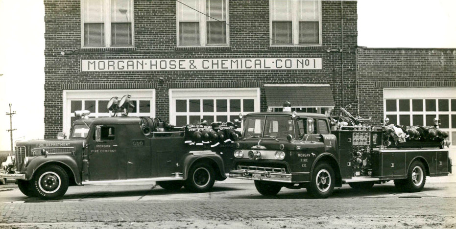
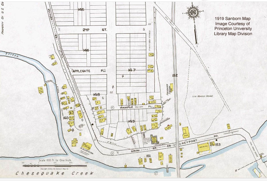
Old Spye Road now is a “dead end” road. It originates at its intersection with Route 35 South where the vacated buildings which used to be Joe’s Kozy Bar & Italian Smorgasbord, and, over time, Kozy Lanes, Club Bene then Crome stood. It swings past the Morgan Hose and Chemical Company No. 1 building (see posting from October 3, 2009) and the “new” Morgan’s Bluff apartments toward private homes as it heads south to Cheesequake Creek. As can be seen in the above 1919 map, at the bottom of the hill, next to the empty site where the Old Spye Inn used to be, the road curves left around the bluff and runs northeasterly toward Raritan Bay in parallel with Cheesequake Creek. The road ends at the dual railroad tracks of New Jersey Transit’s North Jersey Coast Line. Morgan Station, which over time was located at numerous locations at this intersection, used to be a train station and later a train stop but neither are present any longer. The trains now just pass by. Before the railroad crossing was removed (because of the opening of Route 35), the road went another 400’ before heading south over the previous Cheesequake Creek draw bridge.
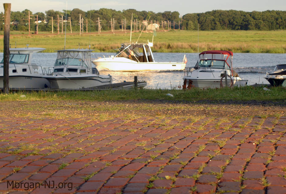
Many Morgan-NJ.org readers have commented about their very fond childhood memories of getting candy at Millie’s Bait shop located where the Misty Morn fishing boat is now. At its peak in the early part of the Twentieth Century, there were a number of businesses on Old Spye Road along the shore of Cheesequake Creek. None of them remain today.
I, for one, am enormously grateful that the Borough of Sayreville has not paved over this fantastic piece of remaining Morgan history and, in fact, a little maintenance appears to have been done near where the “new” Morgan’s Bluff apartments are located in what was Kozy’s parking lot (across the street from the firehouse). Grace [Hendershot] O’Keefe, who grew up on Old Spye Road and whose late father was a Morgan history expert, indicated that twice in her memory the Borough wanted to pave it but the residents successfully fought it. I hope it stays forever brick.
Bonus Info
Did you ever wonder if there are any other streets like Old Spye Road still featuring C. P. Mayer paving blocks? You need to look no farther than Bridgeville, PA itself!
There are a number of streets in Bridgeville featuring C. P. Mayer paving blocks that appear to be in relatively good shape despite being over 100 years old and having gone through an equal number of harsh Pittsburgh area winters. These streets are all in the same neighborhood: Chestnut Street, Dewey Avenue, Elm Street, Gregg Avenue, and McMillan Street.
Originally posted February 14, 2010. Revised October 12, 2021.