Morgan Memories – Morgan Station
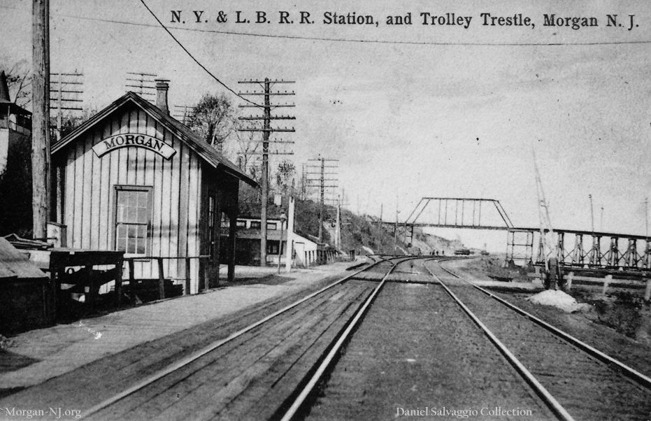
Morgan Station, Circa 1905, Looking Northward from Cheesequake Creek. Picture Post Card Image Courtesy of Mr. Daniel Salvaggio.
Morgan Station would certainly qualify as one of those things categorized as “Something which isn’t there anymore.” In my early days of research for this web site, as I was reviewing the US Army Corps of Engineers documents regarding Cheesequake Creek, I kept encountering references to “Morgan Station” such as “The soundings were taken with a graduated pole and reduced to the plane of mean low-water as established by the gauge at the draw-bridge near Morgan Station”. Like probably nearly everyone else these days, I didn’t know there ever was an actual Morgan Station or exactly where Morgan Station had been located. In my time in Morgan, there was no train station in Morgan, no observable remains of any type of station, and trains never stopped except perhaps in the off chance that the draw bridge over Cheesequake Creek might have been in the open position. My mom used to talk about how people would come to Morgan Beach by train and walk over to the beach from the train station but the first time I ever saw a photo of Morgan Station wasn’t until my school friend Ken Durrua showed me a photo out of the excellent September 1985 book, The Unique New York & Long Branch by Don Wood, Joel Rosenbaum and Tom Gallo. BTW, I highly recommend this book which gives the history of the railroad and has a great number of photos covering its history.
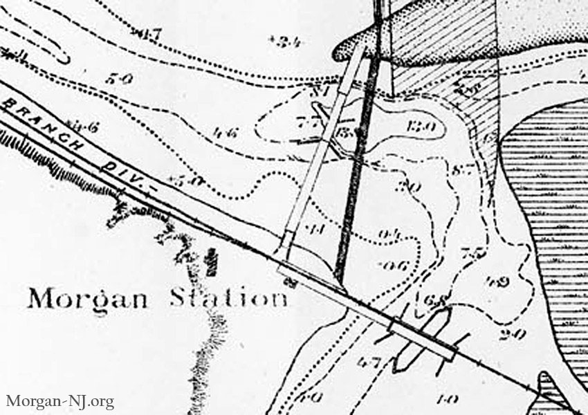
1882 US Army Corps of Engineers Sketch Showing the Location of Morgan Station, Original Mouth of Cheesequake Creek, and Earlier Road and Railroad Bridges over Cheesequake Creek.
In the horse and buggy days, when present day Old Spye Road was the “County Road,” composed of dirt, not highly travelled but was the main passage way to Monmouth County and shore line points further south from the north, it wouldn’t matter where a train would stop to load and unload people or cargo. In the mid 1870’s, when the railroad was constructed then opened for operation, railroads were the main form of transportation. So when the New York & Long Branch Railroad (NY&LB RR) established the stopping point for Morgan, it put the station on the Morgan side of Cheesequake Creek right next to the at-the-time swing bridge crossing over it. This would have meant that when the trains stopped, they would block the passageway of the county’s dirt road. Since this was in the 1870’s, there were no cars, buses or trucks (or RVs) – only horses, horse drawn wagons, and pedestrians. Bicycles didn’t become popular until the 1890’s, some 15 years hence. In other words, it didn’t matter where the train stopped – it was the big dog. That would change in the future.
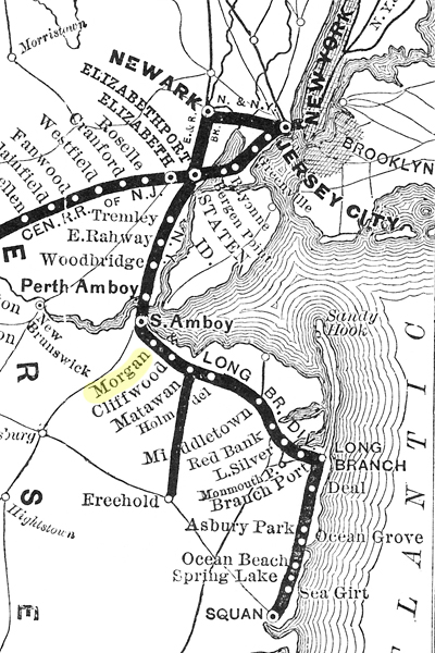
1878 Map of the Central New Jersey Railroad, New York & Long Branch Division Highlighting the Location of Morgan Station.
The first and main photo for this posting is the same photo I saw in the book, The Unique New York & Long Branch. This specific image is from a picture post card provided to me by Mr. Daniel Salvaggio. I met Mr. Salvaggio, and his daughter Maria, at our August 27, 2011 Morgan Reunion Dinner at Teddy’s Bar. Mr. Salvaggio had a folder full of Morgan post cards, newspaper articles and ads, restaurant menus, business cards, and photos which he graciously loaned to me. Some of the rest of this fantastic collection will definitely be incorporated into this web site with much appreciation by me toward Mr. Salvaggio. I would also like to give thanks to Randy Gabrielan for also providing me a copy of this same image which he recently found in the records of the Monmouth County Historical Society. I was introduced to Randy in 2011 because we both have a shared interest in local New Jersey history as well as a specific interest in the Morgan based T. A. Gillespie Loading Company and the disastrous explosions there of October 1918. Randy has authored a number of books on local New Jersey history which are available in many places, including Amazon.com, and I highly recommend them. I especially recommend his “Explosion in Morgan” book which was published in 2012. I was also able to meet Randy at our August 27 Morgan history tour where he stayed the whole day with us.
Randy has looked at photocopies of the handwritten deeds with [presumably James Rutus] Morgan as the grantor to the New York & Long Branch Railroad. Randy must be amazing as I have enormous trouble being able to read handwritten deeds, much less ones which were photocopied however many times! Per Randy,
The first deed was recorded in July 1872 and was a transaction which was only regarding a right of way. The key provision was that the Morgans were retaining the rights to the clay they were mining in the vicinity. In June of 1873 they sold a tract to the railroad for $1,000, which then was not exactly a gift considering what the railroad was going to do for property values. There is no mention of a naming consideration at a time when a station may not have even been determined.
When the June 12, 1875 Matawan Journal listed the stations which were to be on the about to open New York & Long Branch Railroad, they listed Cheesequake as the station 1.65 miles south of South Amboy. The railroad time tables listed this station as Morgan and clearly the station’s name was Morgan Station. I’m not quite sure what to make of this. Could it have been the case that the station was originally going to be called Cheesequake but ultimately was called Morgan or did the newspaper just make a mistake that day? There have been discussions that James Rutus Morgan sold the right of way to the railroad for $1 in lieu of the creation of a station with the name Morgan on it. If this was the case, we haven’t found the supporting documentation yet.
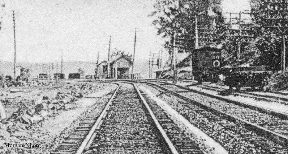
Looking Southward Under the Jersey Central Traction Company Bridge Toward Morgan Station, Circa 1905.
The photo at the top of this posting is the best of only two photographs I am aware of – so far – which show what might have been the original Morgan Station building. Both photographs were on picture post cards from the very early 1900’s and appear to have been taken around the same time frame. A very zoomed in portion of the second post card is also included in this posting showing what appears to be two buildings on the west side of the railroad tracks at Morgan Station as seen while looking southward under the Jersey Central Traction Company’s bridge spanning the NY&LB RR tracks in Morgan. Since this close up photo doesn’t show the crossing gates where the county road crosses the railroad tracks, I conclude this photo is somewhat older than the photo at the top of this posting. I have to say both of these post cards are among my personal favorites. Mr. Salvaggio’s picture post card shows one building but that doesn’t mean there wouldn’t have been a second building to the immediate left of the photographer.
I don’t have all the facts but I think there have been at least four different structures which have served as “Morgan Station.” Photos of three of them are contained in this posting, unless two of them are actually the same building, as well as a map showing the location of the fourth. Perhaps there were other structures. If any of the readers have anything to add, by all means please contact me so I can add it.
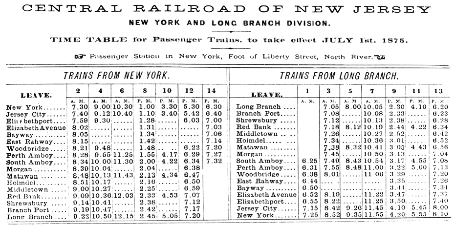
First Schedule of the New York and Long Branch Railroad, Dated July 1, 1875, Showing Scheduled Stops at Morgan Station. Image from the Book The Unique New York & Long Branch. Used with Permission from the Joel Rosenbaum and Tom Gallo Collection.
I don’t really have any record of whether there was an actual station structure in Morgan when the railroad was opened in July of 1875. However, the 1882 US Army Corps of Engineers proposed improvements to “Cheesequakes Creek” sketch shows a small Morgan Station rectangle at the intersection of the railroad and the county road bridge. This is the same location as the small Morgan Station building with the “Morgan” sign seen on the picture post card. While I don’t have an exact date of the picture post card photo, it could not have been much earlier than 1905. The trestle crossing the railroad tracks in the background was for the Jersey Central Traction trolley company which, according to Joseph Eid’s book, Jersey Central Traction Co., had its initial run on Thursday, March 16, 1905 from Keyport through Morgan to the Morgan/South Amboy boundary line at present day Christ Church Cemetery where the line ended at that time.
The condition of the wood making up the Morgan Station building in the picture post card appears to be in excellent shape which would mean that it could not have been 30 years old thus raising the question of whether there had been a different structure there prior. I love both the vertical stripes on the building, perhaps caused by the overlapping of the wood on the station, and the curved “Morgan” sign! Maybe Mr. Joseph Siwiec (see the to-be-reposted write-up on the model of the Old Spye Inn) would build a model of this someday. This small station appears to have had a small enclosed room, perhaps for ticket sales or an enclosed waiting area, as well as a small covered waiting area.
The summer of 1913 was a very busy construction period in the area surrounding Morgan Station (see the history of the Bridges of Cheesequake Creek page). The pivot type of railroad bridge was replaced by the current Sherzer type single leaf rolling lift draw bridge. At the same time the second County Road bridge over Cheesequake Creek was replaced by a draw bridge, and as per the August 16, 1913 South Amboy Citizen:
The railroad station at Morgan has been moved several hundred feet northward, and the platform has been extended, making a decided improvement. Electric lights will be placed along the approach to the station.
In the following week’s issue, the Citizen indicated the station also had had a paint job,
Morgan Station now shows signs of improvement. It has received its yearly coat of paint and looks quite natty.
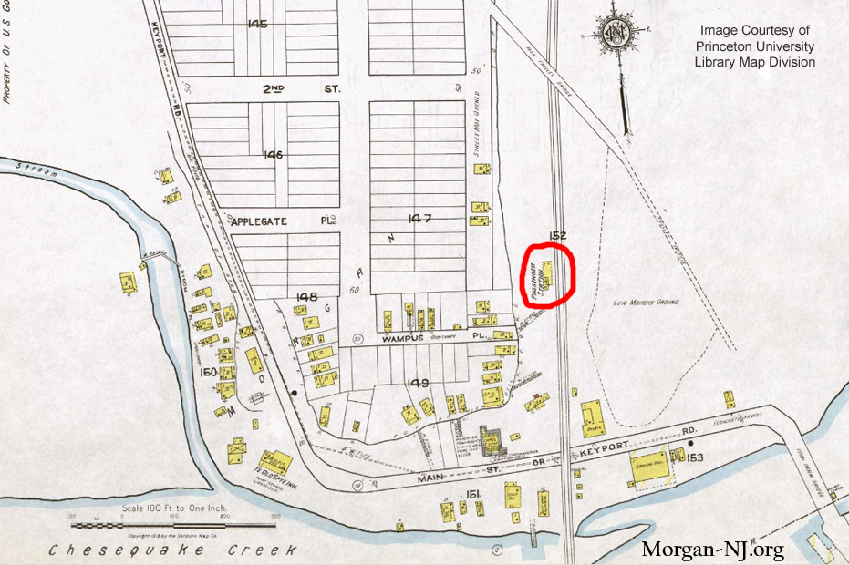
1919 Sanborn Map Showing the Location of Morgan Station at the Time. Image Courtesy of Princeton University Library Map Division.
I believe the new location discussed in the Citizen was as is shown on Sheet 13 of the 1919 Sanborn Map. It seems that this new location of the Morgan Station would have allowed for trains – at least for south bound trains – to be less interruptive of the new-fangled automobile and truck traffic on the county road which crossed the railroad tracks at ground level at this location.
Morgan Station became a very important stopping point when the T. A. Gillespie Loading Company was built in 1918. In April of the previous year, the US declared war on Germany which shortly thereafter caused the construction of the Gillespie “Morgan Plant” – one of the world’s largest, if not the largest, artillery shell loading plants in the world. Eventual access for many of the plant’s workers was via the Jersey Central Traction trolley or the railroad which stopped at Morgan Station. One of the Morgan-NJ.org readers wrote to me suggesting that perhaps the sluiceway over Back or Crossways Creek (see to-be-reposted write-up on the Sluiceway Bridge), right near where Morgan Station used to be, was an entry way into the T. A. Gillespie Loading Company plant. This seems possible. I don’t have anything which confirms this or rules it out at this time so maybe.
The plant blew up in October of 1918 and the war ended five weeks later on November 11 thus significantly diminishing the need to have a ticket agency. Less than two years later, the February 21, 1920 edition of the South Amboy Citizen reported that the ticket office at Morgan was going to be discontinued.
Discontinuance of the ticket agency of the New York & Long Branch Railroad at Morgan has been sanctioned by the Board of Public Utility Commissioners upon the application of the railroad and director general. It was contended by the railroad that travel at this point has decreased to such an extent that the maintenance of a ticket agency, as a war measure, is no longer a necessity. It was originally established to accommodate employes of the Gillespie loading plant.
In the early 1920s, with the advent and huge growth in the use of and private ownership of the automobile – thanks to Mr. Ford for making car ownership affordable to the average person – the intersection of what was then known as Main Street or Keyport Road (now known as Old Spye Road) with the railroad at Morgan Station was getting problematic. The June 2, 1921 issue of The Matawan Journal stated that on Memorial Day between 16,000 and 18,000 cars passed through Matawan. All of these cars would also have had to have passed over the railroad tracks at Morgan Station.
The grade crossing’s massive traffic jams of the early 1920’s became too great thus leading the state to come up with another approach – literally. Ultimately the traffic jams, as well as the grade level railroad crossing itself, came to an abrupt end with the July 1925 opening of the present day Route 35 Pratt trestle bridge over the railroad. This bridge and the land fill ramp leading up to it from Cheesequake Creek were built atop the site previously containing the Jersey Central Traction Company (trolley) trestle and bridge. The trestle and bridge were removed sometime following the demise of the Jersey Central Traction Company which, again according to Mr. Eid’s book, ended operations almost exactly two years earlier at midnight on July 28, 1923.
This unexpected closing of the grade level railroad crossing came as a surprise to many – especially the local merchants – and decimated of all the businesses along this stretch of the road parallel to the creek. Perhaps one of these casualties was James H. Cady who had a restaurant somewhere in Morgan as of 1922. Mr. Cady opened his Cady’s House of Sea Food in early 1926 right along the new route of the “Shore Road” (present day Route 35) on the north side of the Cheesequake Creek channel between the Morgan Bridge over Cheesequake Creek and the base of the road’s incline. As discussed in the to-be-reposted Robert E. Lee Inn write-up, Cady’s House of Sea Food later became the Robert E. Lee Inn.
Refuse to Open Morgan Crossing. Both Railroad and State Highway Reject Pleas of Residents…
In the month following the opening of the new bridge over the railroad tracks, the residents of Morgan asked the railroad to replace the “present shelter shed at Morgan with an enclosed structure that can be suitably heated during the winter months.” Here is the article from the August 7, 1925 South Amboy Citizen newspaper:
A petition is now being circulated among the residents of Morgan Heights and Morgan Beach favoring the replacement of the present shelter shed at Morgan with an enclosed structure that can be suitably heated during the winter months. The petition cites the fact that the popular resort is rapidly charging from one having a large summer population that dwindles to almost nothing in winter, to one that is being made the year-round residence of an increasing number of commuters to Newark, New York and other points in the metropolitan area. The inadequateness of the shelter that now [is] used is brought out by a comparison of its capacity to protect perhaps a dozen people in time of storm with a crowd that numbered nearly five hundred persons, all of whom boarded a single train on a Sunday evening recently. The petition is being freely signed as endorsement of the idea by commuters and residents of Morgan and it is predicted that the railroad authorities will be influenced toward immediate action by the resentment held by many residents of Morgan because of the closing of the road crossing there recently.
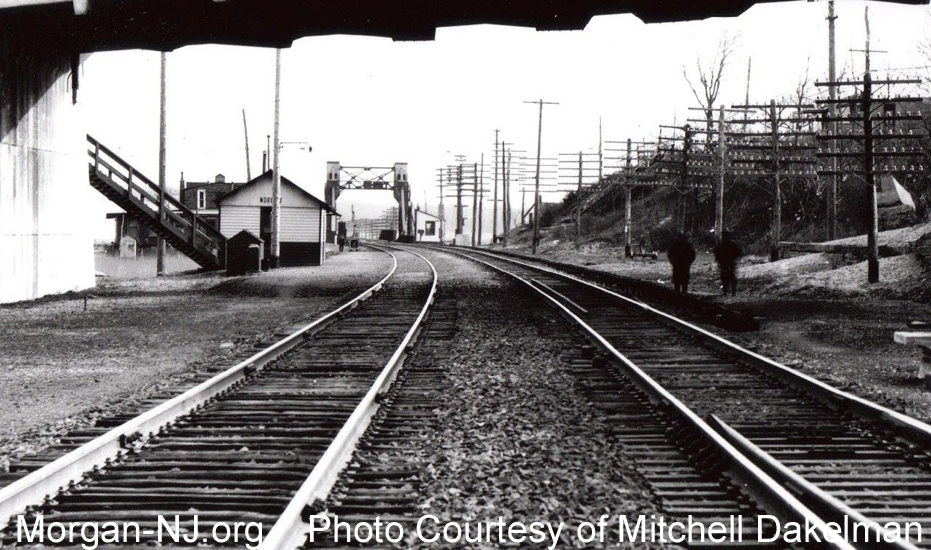
Morgan Station Shelter and Cheesequake Creek Draw Bridge as Viewed Looking Southward Under the Route 35 Bridge Over the New York & Long Branch Railroad on February 3, 1928. Photo Courtesy of Mitchell Dakelmann.
As can be seen in this February 3, 1928 photo, by this time Morgan Station was still a partially enclosed shelter shed. It isn’t clear yet when the location of the shelter was moved from the 1919 location on the southbound side of the tracks as shown in the Sanborn Map to the northbound side shown in this photo. It would seem likely this was done in coordination with the July 1926 opening of the Shore Road as evidenced by there being a staircase from the road down to the shelter. When compared to the above photos of this posting from the very early 1900’s, it appears as if the third track portion and the stair cases between the railroad and the residences at the top of the bluff between the new bridge and the road bridge intersection had been removed.
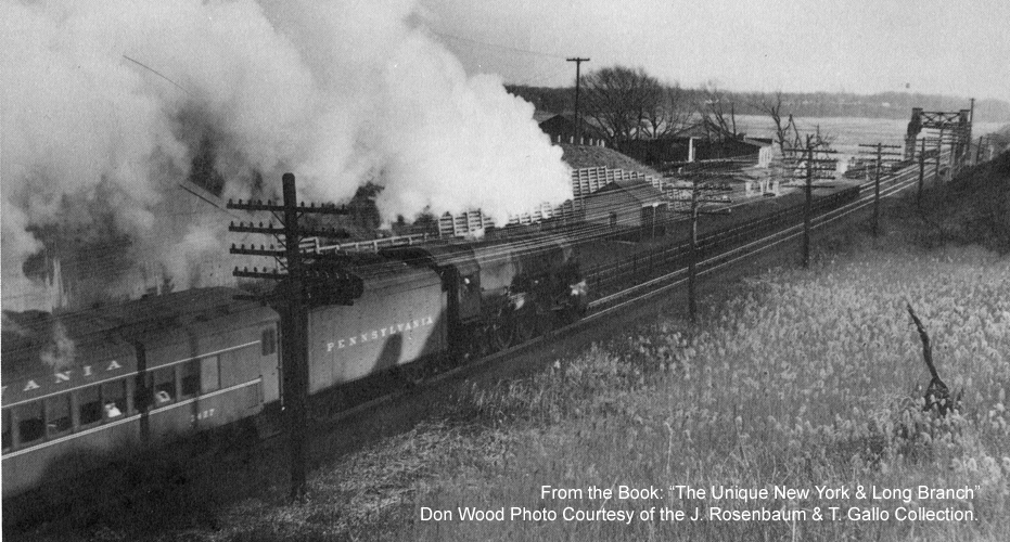
Passenger Train at Morgan Station in 1954. Photo by Don Wood. Image from the Book The Unique New York & Long Branch. Used with Permission from the Joel Rosenbaum and Tom Gallo Collection.
This 1954 Don Wood photo shows a southbound passenger train being pulled by Pennsylvania Railroad’s K4 locomotive #1120. Based on the lack of foliage on the trees and the angle of the sun, this photo would have been taken a short time before sunset during the fall or winter thus likely making it a commuter train traveling from New York City to Long Branch.
Between the 1928 photo above and this 1954 photo, another major change to the Route 35 roadway had occurred. The present day elevated Morgan draw bridge replaced the creek level draw bridge in the early days of World War II, another two lane bridge over the railroad tracks was later constructed to contain the two southbound lanes of Route 35, the landfill with a concrete interlaced support wall appears to have been widened between the two new road bridges to support the two additional lanes, and an access road was added on the Route 35 southbound lane side to connect to the remains of the old road along Cheesequake Creek. Without this access road, there would have been no way to access the Henry Luhrs Sea Skiff facility, the Robert E. Lee Inn, the sewage pumping plant, and anything else in that area except by boat. The location of the shelter shed appears to have been moved closer to Cheesequake Creek and, it seems, the shelter shed structure either altered or replaced by a new similar shed (hence why I’m not sure if that was Morgan Station #3 or #4). By 1954, the Railroad also appears to have added a fence between the tracks.
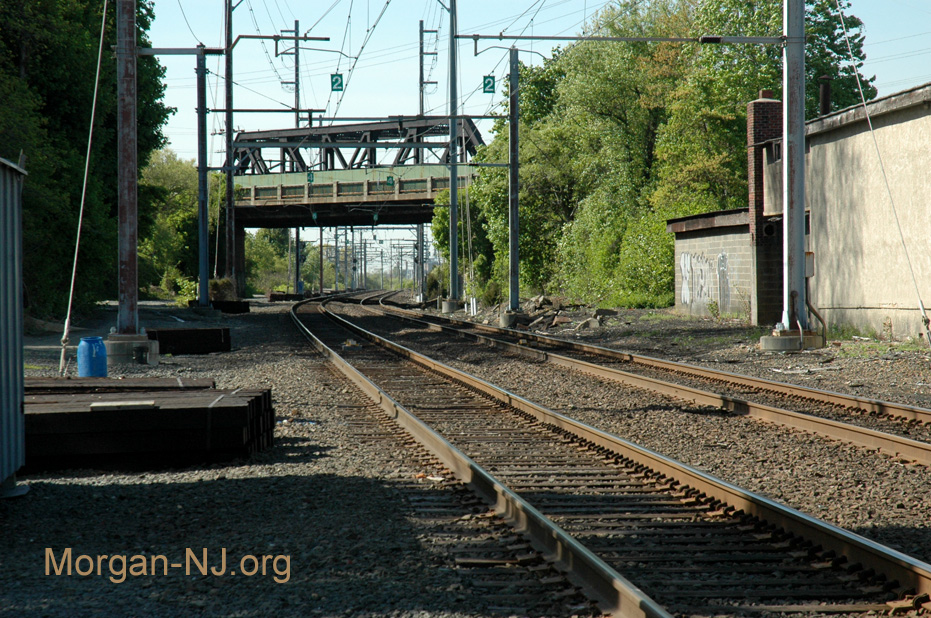
Looking Northward from the Original Location of Morgan Station in May 2005.
With one exception so far (see Steam Train Passing Through Morgan in 1954), the last steam train passed through Morgan in late 1957. I have not yet discovered when the last train – whether steam or diesel – stopped to pick up or let off passengers at Morgan Station but can’t imagine it was much later than the end of the 1950’s. If I find the date, I’ll let you know and would ask for any of you to please do the same if you find out first. Today, as it was when I lived in Morgan, there are absolutely no remains of any of the foundations or structures making up any of the Morgan Stations. Based solely on the physical artifacts in this area between the Route 35 overpass and the NJ Transit bridge over Cheesequake Creek, you would never know that there ever was a Morgan Station in Morgan.
Originally posted on January 29, 2012. Links updated August 26, 2018.
Having grown up on “causeway creek” that branched off Cheesequake Creek, I vividly recall
taking the train in the 1950s (Then, only the Jersey Central would stop at Morgan and only on demand
or “flagging” the train to get aboard). More specifically, my father (John Z. Adams) used
the train on occasion (Usually during snow storms) to get to work at the Raritan Copper
Works at the foot of Elm Street – a short walk from the Perth Amboy train station.
When my grandfather and I used to walk down Old Spy Rd. to the Robt. E. Lee, circa 1957, I clearly recall the old station building, dilapidated, but exactly as pictured. My grandfather, for a time, took the train to and from his job. He would come and go via this station.
I was just researching Morgan Station because a photo album I bought at an auction has a few original photos from 1915/1916. If you are interested I could forward you pictures of them.
Hi Rick! I just sent you an email. It would be fabulous to be able to see those photos! Thanks, Verne