Morgan Moments – 1937 Cheesequake Creek from the Air
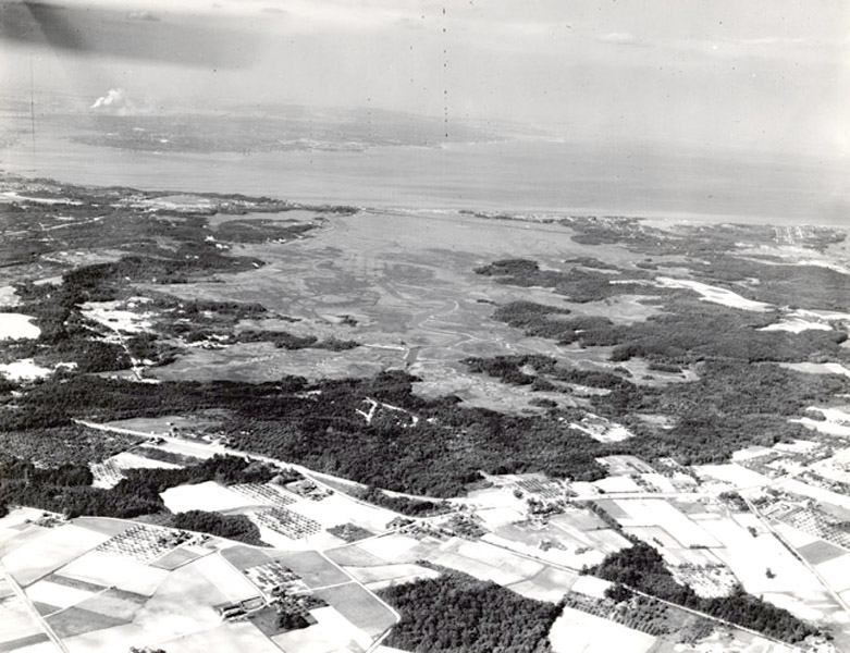
Aerial Photo of Cheesequake Creek in 1937 from the NJ State Archives Web Site.
I know, another Cheesequake Creek related page! Who knew?
I found this amazing 1937 aerial photo on the NJ State Archives web site. It is looking east across Cheesequake Creek toward Raritan Bay and Staten Island. Here is what I notice, what about you?
- Lots of farms in OldBridge in the foreground! Before the advent of cheap and readily available ground transportation, farms in this area used Cheesequake Creek as the way of shipping in supplies (e.g., manure) and shipping out products (e.g., produce).
- The triangular main road intersection seen in the foreground is where Route 34, Spring Hill Road and Old Mill Road come together. These roads are still there today.
- Route 9 is barely seen at the bottom left.
- CheesequakeState Park was established a few years after this photo was taken.
- The Garden State Parkway would not cut across the Cheesequake Creek basin for another 16 years.
- In the distance, you can see the railroad track cut diagonally across the basin. That, too, is still there.
- Route 35 still had the double leaf bascule draw bridge drawbridge at the time.
- Whitehead Dock and Ernst’s Dock were located at or near the portion of the creek closest to the camera which somewhat has the shape of an arrowhead. There is still an unpaved road (Dock Road) showing on maps in this area.
- Looks like it was high tide at the time the photo was taken.
- The area where Lockwood Boat Works is now located appears to be entirely underwater!
- The portion of Morgan bordered to the north by Luke Street and to the east by Midland Avenue appears completely treeless and houseless. Like the Yankees now, it is also Ruth less.
- You can see the at-the-time new Route 35 cutting across the top left 1/3 of the photo.
- Toward the top left you can just barely see portions of Perth Amboy and, to the left of the smoke from the smoke stack on Staten Island, the Outerbridge Crossing spanning the Arthur Kill (Kill is Dutch for riverbed or water channel). Did you know that the Outerbridge Crossing was named for Eugenius Harvey Outerbridge who was the first chairman of the then named Port of New York Authority (now known as the Port Authority of New York and New Jersey)? They didn’t name it the OuterbridgeBridge for obvious reasons and it also wasn’t named Outerbridge because it was so far away from anything.
- All the way to the right and 1/3 of the way down from the top you can see what are probably Furman Boulevard, Raritan Boulevard and Ocean Boulevard in CliffwoodBeach. They kind of look like airport runways, don’t they? Just to the right of these three streets is a smaller wetlands area I believe is known as Whale Creek. Except for its size, note its similarities to Cheesequake Creek.
Let us know what you notice in the comments below.
Originally posted on March 9, 2011.